You are here: Home > Network List > TA - USArray Transportable Network (new EarthScope stations) Stations List
> Station G54A Lake Saint Peter, ON, CAN > Earthquake Result Viewer
G54A Lake Saint Peter, ON, CAN - Earthquake Result Viewer
| Earthquake location: |
Chiapas, Mexico |
| Earthquake latitude/longitude: |
17.2/-94.9 |
| Earthquake time(UTC): |
2014/05/21 (141) 10:06:14 GMT |
| Earthquake Depth: |
128 km |
| Earthquake Magnitude: |
5.6 MWP |
| Earthquake Catalog/Contributor: |
NEIC PDE/NEIC COMCAT |
|
| Network: |
TA USArray Transportable Network (new EarthScope stations) |
| Station: |
G54A Lake Saint Peter, ON, CAN |
| Lat/Lon: |
45.40 N/78.09 W |
| Elevation: |
465 m |
|
| Distance: |
31.5 deg |
| Az: |
23.005 deg |
| Baz: |
212.021 deg |
| Ray Param: |
0.07871699 |
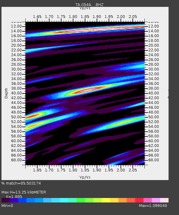
| Estimated Moho Depth: |
13.25 km |
| Estimated Crust Vp/Vs: |
1.88 |
| Assumed Crust Vp: |
6.577 km/s |
| Estimated Crust Vs: |
3.489 km/s |
| Estimated Crust Poisson's Ratio: |
0.30 |
|
| Radial Match: |
85.503174 % |
| Radial Bump: |
400 |
| Transverse Match: |
62.899826 % |
| Transverse Bump: |
400 |
| SOD ConfigId: |
626651 |
| Insert Time: |
2014-06-04 10:46:36.627 +0000 |
| GWidth: |
2.5 |
| Max Bumps: |
400 |
| Tol: |
0.001 |
|

Signal To Noise
| Channel | StoN | STA | LTA |
| TA:G54A: :BHZ:20140521T10:11:54.12501Z | 29.447296 | 2.2735906E-6 | 7.720881E-8 |
| TA:G54A: :BHN:20140521T10:11:54.12501Z | 28.869171 | 1.4221895E-6 | 4.926326E-8 |
| TA:G54A: :BHE:20140521T10:11:54.12501Z | 15.544809 | 9.377559E-7 | 6.032598E-8 |
| Arrivals |
| Ps | 1.9 SECOND |
| PpPs | 5.4 SECOND |
| PsPs/PpSs | 7.3 SECOND |


