You are here: Home > Network List > TA - USArray Transportable Network (new EarthScope stations) Stations List
> Station M62A Hamden, CT, USA > Earthquake Result Viewer
M62A Hamden, CT, USA - Earthquake Result Viewer
| Earthquake location: |
Chiapas, Mexico |
| Earthquake latitude/longitude: |
17.2/-94.9 |
| Earthquake time(UTC): |
2014/05/21 (141) 10:06:14 GMT |
| Earthquake Depth: |
128 km |
| Earthquake Magnitude: |
5.6 MWP |
| Earthquake Catalog/Contributor: |
NEIC PDE/NEIC COMCAT |
|
| Network: |
TA USArray Transportable Network (new EarthScope stations) |
| Station: |
M62A Hamden, CT, USA |
| Lat/Lon: |
41.44 N/72.89 W |
| Elevation: |
24 m |
|
| Distance: |
30.7 deg |
| Az: |
33.516 deg |
| Baz: |
224.593 deg |
| Ray Param: |
0.0790362 |
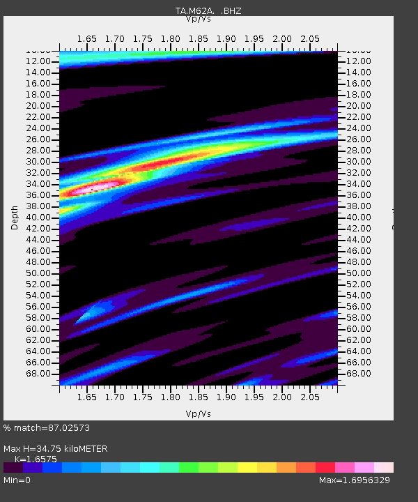
| Estimated Moho Depth: |
34.75 km |
| Estimated Crust Vp/Vs: |
1.66 |
| Assumed Crust Vp: |
6.472 km/s |
| Estimated Crust Vs: |
3.905 km/s |
| Estimated Crust Poisson's Ratio: |
0.21 |
|
| Radial Match: |
87.02573 % |
| Radial Bump: |
400 |
| Transverse Match: |
50.870373 % |
| Transverse Bump: |
400 |
| SOD ConfigId: |
626651 |
| Insert Time: |
2014-06-04 10:50:43.595 +0000 |
| GWidth: |
2.5 |
| Max Bumps: |
400 |
| Tol: |
0.001 |
|
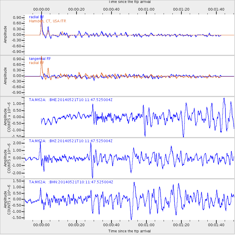
Signal To Noise
| Channel | StoN | STA | LTA |
| TA:M62A: :BHZ:20140521T10:11:47.525004Z | 6.4038672 | 7.7783756E-7 | 1.2146373E-7 |
| TA:M62A: :BHN:20140521T10:11:47.525004Z | 1.5410831 | 4.1911065E-7 | 2.719585E-7 |
| TA:M62A: :BHE:20140521T10:11:47.525004Z | 1.6868739 | 3.6040257E-7 | 2.1365116E-7 |
| Arrivals |
| Ps | 3.9 SECOND |
| PpPs | 13 SECOND |
| PsPs/PpSs | 17 SECOND |


