You are here: Home > Network List > US - United States National Seismic Network Stations List
> Station DGMT Dagmar, Montana, USA > Earthquake Result Viewer
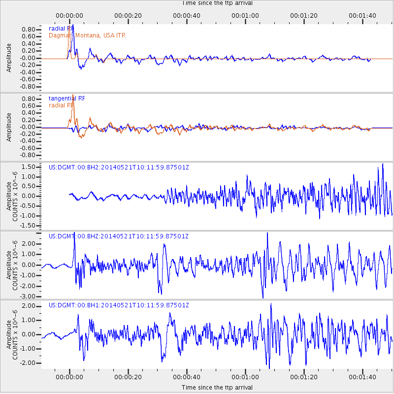
DGMT Dagmar, Montana, USA - Earthquake Result Viewer
*The percent match for this event was below the threshold and hence no stack was calculated.
| Earthquake location: |
Chiapas, Mexico |
| Earthquake latitude/longitude: |
17.2/-94.9 |
| Earthquake time(UTC): |
2014/05/21 (141) 10:06:14 GMT |
| Earthquake Depth: |
128 km |
| Earthquake Magnitude: |
5.6 MWP |
| Earthquake Catalog/Contributor: |
NEIC PDE/NEIC COMCAT |
|
| Network: |
US United States National Seismic Network |
| Station: |
DGMT Dagmar, Montana, USA |
| Lat/Lon: |
48.47 N/104.20 W |
| Elevation: |
0.0 m |
|
| Distance: |
32.1 deg |
| Az: |
348.35 deg |
| Baz: |
163.139 deg |
| Ray Param: |
$rayparam |
*The percent match for this event was below the threshold and hence was not used in the summary stack. |
|
| Radial Match: |
88.268394 % |
| Radial Bump: |
400 |
| Transverse Match: |
55.57872 % |
| Transverse Bump: |
400 |
| SOD ConfigId: |
626651 |
| Insert Time: |
2014-06-04 10:51:46.678 +0000 |
| GWidth: |
2.5 |
| Max Bumps: |
400 |
| Tol: |
0.001 |
|
Signal To Noise
| Channel | StoN | STA | LTA |
| US:DGMT:00:BHZ:20140521T10:11:59.87501Z | 11.485965 | 1.015815E-6 | 8.843968E-8 |
| US:DGMT:00:BH1:20140521T10:11:59.87501Z | 4.001141 | 5.87872E-7 | 1.4692608E-7 |
| US:DGMT:00:BH2:20140521T10:11:59.87501Z | 1.5985776 | 1.5923882E-7 | 9.961282E-8 |
| Arrivals |
| Ps | |
| PpPs | |
| PsPs/PpSs | |


