You are here: Home > Network List > US - United States National Seismic Network Stations List
> Station LKWY Lake (Yellowstone--Lake), Wyoming, USA > Earthquake Result Viewer
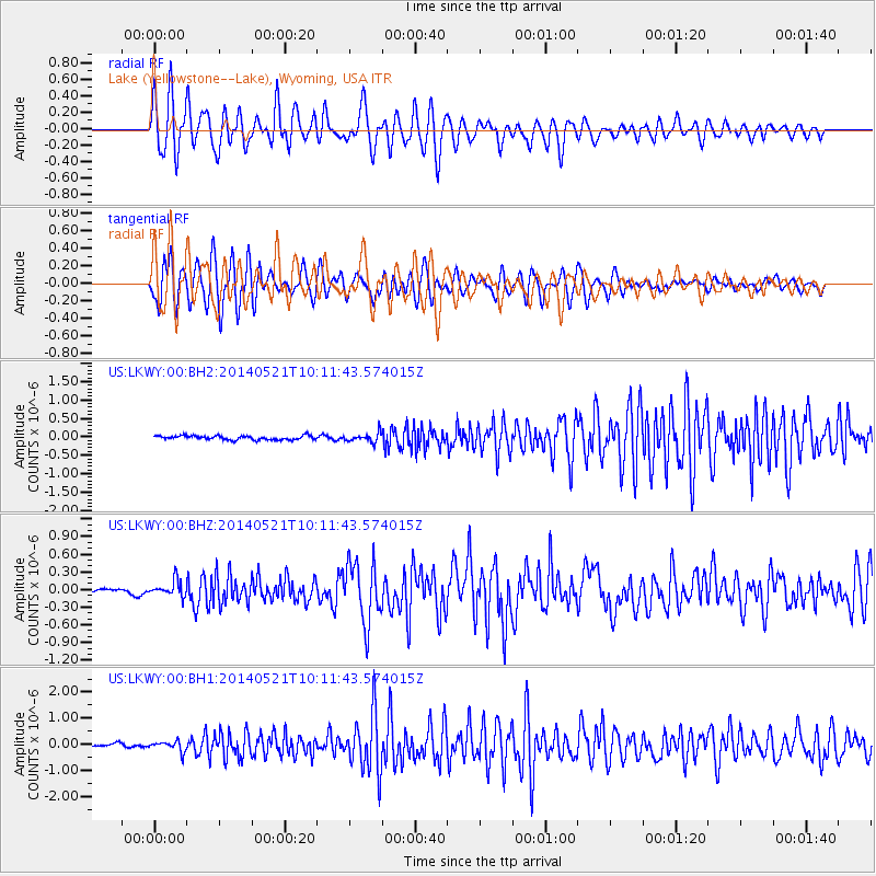
LKWY Lake (Yellowstone--Lake), Wyoming, USA - Earthquake Result Viewer
*The percent match for this event was below the threshold and hence no stack was calculated.
| Earthquake location: |
Chiapas, Mexico |
| Earthquake latitude/longitude: |
17.2/-94.9 |
| Earthquake time(UTC): |
2014/05/21 (141) 10:06:14 GMT |
| Earthquake Depth: |
128 km |
| Earthquake Magnitude: |
5.6 MWP |
| Earthquake Catalog/Contributor: |
NEIC PDE/NEIC COMCAT |
|
| Network: |
US United States National Seismic Network |
| Station: |
LKWY Lake (Yellowstone--Lake), Wyoming, USA |
| Lat/Lon: |
44.57 N/110.40 W |
| Elevation: |
2424 m |
|
| Distance: |
30.2 deg |
| Az: |
337.735 deg |
| Baz: |
149.557 deg |
| Ray Param: |
$rayparam |
*The percent match for this event was below the threshold and hence was not used in the summary stack. |
|
| Radial Match: |
65.34699 % |
| Radial Bump: |
400 |
| Transverse Match: |
72.52187 % |
| Transverse Bump: |
400 |
| SOD ConfigId: |
626651 |
| Insert Time: |
2014-06-04 10:52:06.487 +0000 |
| GWidth: |
2.5 |
| Max Bumps: |
400 |
| Tol: |
0.001 |
|
Signal To Noise
| Channel | StoN | STA | LTA |
| US:LKWY:00:BHZ:20140521T10:11:43.574015Z | 2.472795 | 1.3641927E-7 | 5.516805E-8 |
| US:LKWY:00:BH1:20140521T10:11:43.574015Z | 3.2780125 | 1.9758232E-7 | 6.0275035E-8 |
| US:LKWY:00:BH2:20140521T10:11:43.574015Z | 2.334164 | 1.2622789E-7 | 5.4078413E-8 |
| Arrivals |
| Ps | |
| PpPs | |
| PsPs/PpSs | |


