You are here: Home > Network List > II - Global Seismograph Network (GSN - IRIS/IDA) Stations List
> Station KURK Kurchatov, Kazakhstan > Earthquake Result Viewer
KURK Kurchatov, Kazakhstan - Earthquake Result Viewer
| Earthquake location: |
Lake Tanganyika Region |
| Earthquake latitude/longitude: |
-8.0/30.7 |
| Earthquake time(UTC): |
2000/10/02 (276) 02:25:31 GMT |
| Earthquake Depth: |
34 km |
| Earthquake Magnitude: |
6.1 MB, 6.7 MS, 6.5 MW, 6.2 ME |
| Earthquake Catalog/Contributor: |
WHDF/NEIC |
|
| Network: |
II Global Seismograph Network (GSN - IRIS/IDA) |
| Station: |
KURK Kurchatov, Kazakhstan |
| Lat/Lon: |
50.72 N/78.62 E |
| Elevation: |
184 m |
|
| Distance: |
71.6 deg |
| Az: |
29.814 deg |
| Baz: |
230.77 deg |
| Ray Param: |
0.05416697 |
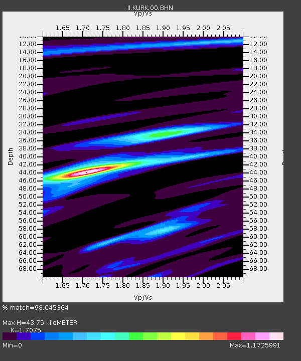
| Estimated Moho Depth: |
43.75 km |
| Estimated Crust Vp/Vs: |
1.71 |
| Assumed Crust Vp: |
6.552 km/s |
| Estimated Crust Vs: |
3.837 km/s |
| Estimated Crust Poisson's Ratio: |
0.24 |
|
| Radial Match: |
98.045364 % |
| Radial Bump: |
277 |
| Transverse Match: |
92.59566 % |
| Transverse Bump: |
400 |
| SOD ConfigId: |
3744 |
| Insert Time: |
2010-03-01 22:29:20.627 +0000 |
| GWidth: |
2.5 |
| Max Bumps: |
400 |
| Tol: |
0.001 |
|
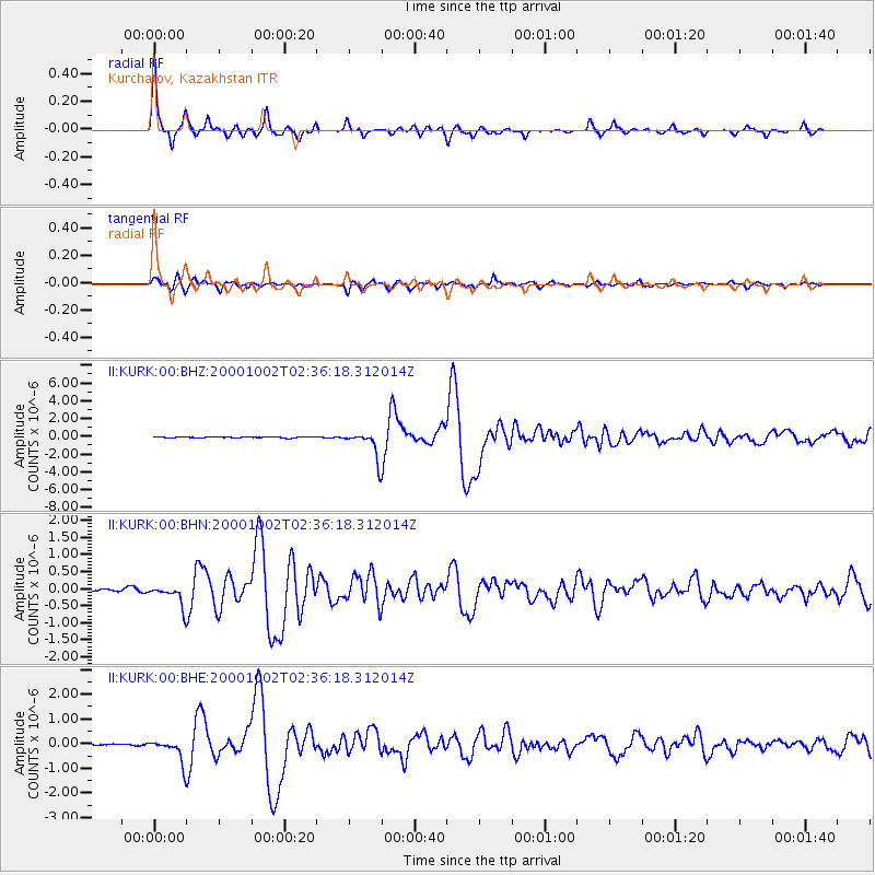
Signal To Noise
| Channel | StoN | STA | LTA |
| II:KURK:00:BHN:20001002T02:36:18.312014Z | 4.4958463 | 2.834644E-7 | 6.305029E-8 |
| II:KURK:00:BHE:20001002T02:36:18.312014Z | 11.729077 | 4.6633957E-7 | 3.975927E-8 |
| II:KURK:00:BHZ:20001002T02:36:18.312014Z | 27.625816 | 1.5286325E-6 | 5.533348E-8 |
| Arrivals |
| Ps | 4.9 SECOND |
| PpPs | 17 SECOND |
| PsPs/PpSs | 22 SECOND |


