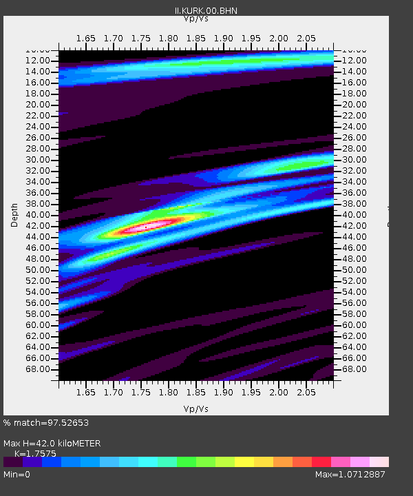
KURK Kurchatov, Kazakhstan - Earthquake Result Viewer
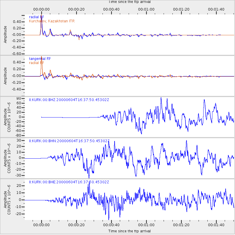
Earthquake location: Southern Sumatra, Indonesia
Earthquake latitude/longitude: -4.7/102.1
Earthquake time(UTC): 2000/06/04 (156) 16:28:26 GMT
Earthquake Depth: 33 km
Earthquake Magnitude: 6.8 MB, 8.0 MS, 7.9 MW, 7.7 MW
Earthquake Catalog/Contributor: WHDF/NEIC
Network: II Global Seismograph Network (GSN - IRIS/IDA)
Station: KURK Kurchatov, Kazakhstan
Lat/Lon: 50.72 N/78.62 E
Elevation: 184 m
Distance: 58.8 deg
Az: 342.784 deg
Baz: 152.354 deg
Ray Param: 0.062553495
Estimated Moho Depth: 42.0 km
Estimated Crust Vp/Vs: 1.76
Assumed Crust Vp: 6.552 km/s
Estimated Crust Vs: 3.728 km/s
Estimated Crust Poisson's Ratio: 0.26
Radial Match: 97.52653 %
Radial Bump: 327
Transverse Match: 90.355736 %
Transverse Bump: 400
SOD ConfigId: 3744
Insert Time: 2010-03-01 22:30:05.481 +0000
GWidth: 2.5
Max Bumps: 400
Tol: 0.001

Signal To Noise

ChannelStoNSTALTA
II:KURK:00:BHN:20000604T16:37:50.45302Z4.04881059.552051E-72.3592241E-7
II:KURK:00:BHE:20000604T16:37:50.45302Z4.2212693.930034E-79.310077E-8
II:KURK:00:BHZ:20000604T16:37:50.45302Z5.00812152.1595338E-64.3120633E-7
Arrivals
Ps5.1 SECOND
PpPs17 SECOND
PsPs/PpSs22 SECOND