You are here: Home > Network List > TA - USArray Transportable Network (new EarthScope stations) Stations List
> Station POKR Poker Plat Research Range, AK, USA > Earthquake Result Viewer
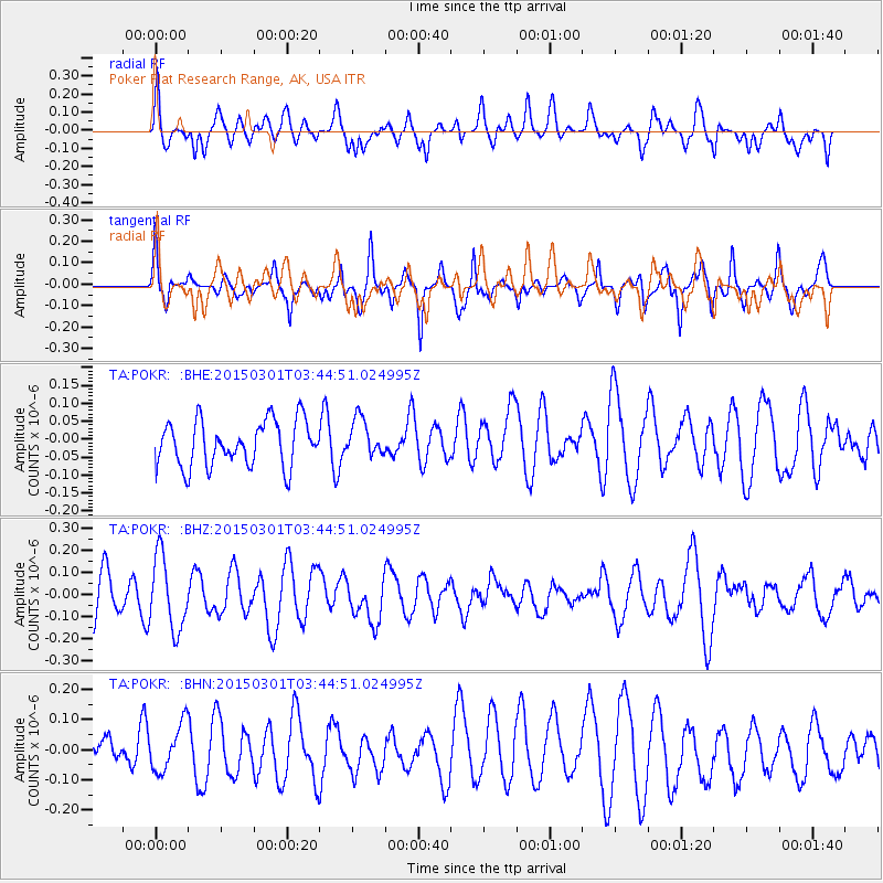
POKR Poker Plat Research Range, AK, USA - Earthquake Result Viewer
*The percent match for this event was below the threshold and hence no stack was calculated.
| Earthquake location: |
Minahassa Peninsula, Sulawesi |
| Earthquake latitude/longitude: |
0.0/124.4 |
| Earthquake time(UTC): |
2015/03/01 (060) 03:32:36 GMT |
| Earthquake Depth: |
90 km |
| Earthquake Magnitude: |
5.6 MW |
| Earthquake Catalog/Contributor: |
ISC/ISC |
|
| Network: |
TA USArray Transportable Network (new EarthScope stations) |
| Station: |
POKR Poker Plat Research Range, AK, USA |
| Lat/Lon: |
65.12 N/147.43 W |
| Elevation: |
501 m |
|
| Distance: |
89.2 deg |
| Az: |
25.019 deg |
| Baz: |
268.341 deg |
| Ray Param: |
$rayparam |
*The percent match for this event was below the threshold and hence was not used in the summary stack. |
|
| Radial Match: |
51.4669 % |
| Radial Bump: |
400 |
| Transverse Match: |
59.22326 % |
| Transverse Bump: |
400 |
| SOD ConfigId: |
7019011 |
| Insert Time: |
2019-04-17 03:41:33.067 +0000 |
| GWidth: |
2.5 |
| Max Bumps: |
400 |
| Tol: |
0.001 |
|
Signal To Noise
| Channel | StoN | STA | LTA |
| TA:POKR: :BHZ:20150301T03:44:51.024995Z | 1.6035316 | 1.6405075E-7 | 1.02305904E-7 |
| TA:POKR: :BHN:20150301T03:44:51.024995Z | 1.1871953 | 8.015548E-8 | 6.751667E-8 |
| TA:POKR: :BHE:20150301T03:44:51.024995Z | 0.8426422 | 5.2973313E-8 | 6.286572E-8 |
| Arrivals |
| Ps | |
| PpPs | |
| PsPs/PpSs | |


