You are here: Home > Network List > TA - USArray Transportable Network (new EarthScope stations) Stations List
> Station J04D Umpqua National Forest, Toketee, OR, USA > Earthquake Result Viewer
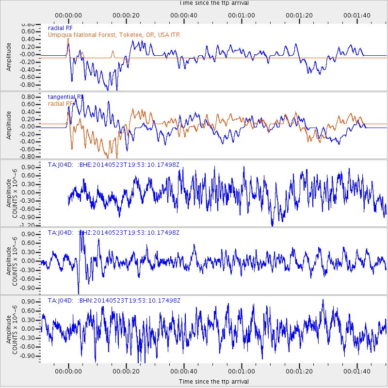
J04D Umpqua National Forest, Toketee, OR, USA - Earthquake Result Viewer
*The percent match for this event was below the threshold and hence no stack was calculated.
| Earthquake location: |
East Of Lake Baykal, Russia |
| Earthquake latitude/longitude: |
56.1/114.0 |
| Earthquake time(UTC): |
2014/05/23 (143) 19:42:28 GMT |
| Earthquake Depth: |
10 km |
| Earthquake Magnitude: |
5.6 MB |
| Earthquake Catalog/Contributor: |
NEIC PDE/NEIC COMCAT |
|
| Network: |
TA USArray Transportable Network (new EarthScope stations) |
| Station: |
J04D Umpqua National Forest, Toketee, OR, USA |
| Lat/Lon: |
43.24 N/122.11 W |
| Elevation: |
1948 m |
|
| Distance: |
70.3 deg |
| Az: |
40.12 deg |
| Baz: |
330.425 deg |
| Ray Param: |
$rayparam |
*The percent match for this event was below the threshold and hence was not used in the summary stack. |
|
| Radial Match: |
58.702618 % |
| Radial Bump: |
400 |
| Transverse Match: |
50.676693 % |
| Transverse Bump: |
400 |
| SOD ConfigId: |
626651 |
| Insert Time: |
2014-06-06 20:45:30.101 +0000 |
| GWidth: |
2.5 |
| Max Bumps: |
400 |
| Tol: |
0.001 |
|
Signal To Noise
| Channel | StoN | STA | LTA |
| TA:J04D: :BHZ:20140523T19:53:10.17498Z | 3.0708065 | 4.1859292E-7 | 1.3631367E-7 |
| TA:J04D: :BHN:20140523T19:53:10.17498Z | 0.6496818 | 2.672349E-7 | 4.11332E-7 |
| TA:J04D: :BHE:20140523T19:53:10.17498Z | 0.91540706 | 2.50225E-7 | 2.7334835E-7 |
| Arrivals |
| Ps | |
| PpPs | |
| PsPs/PpSs | |


