You are here: Home > Network List > TA - USArray Transportable Network (new EarthScope stations) Stations List
> Station R11A Troy Canyon, Currant, NV, USA > Earthquake Result Viewer
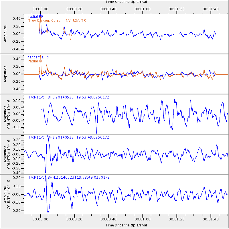
R11A Troy Canyon, Currant, NV, USA - Earthquake Result Viewer
*The percent match for this event was below the threshold and hence no stack was calculated.
| Earthquake location: |
East Of Lake Baykal, Russia |
| Earthquake latitude/longitude: |
56.1/114.0 |
| Earthquake time(UTC): |
2014/05/23 (143) 19:42:28 GMT |
| Earthquake Depth: |
10 km |
| Earthquake Magnitude: |
5.6 MB |
| Earthquake Catalog/Contributor: |
NEIC PDE/NEIC COMCAT |
|
| Network: |
TA USArray Transportable Network (new EarthScope stations) |
| Station: |
R11A Troy Canyon, Currant, NV, USA |
| Lat/Lon: |
38.35 N/115.59 W |
| Elevation: |
1756 m |
|
| Distance: |
76.9 deg |
| Az: |
37.921 deg |
| Baz: |
334.056 deg |
| Ray Param: |
$rayparam |
*The percent match for this event was below the threshold and hence was not used in the summary stack. |
|
| Radial Match: |
61.837852 % |
| Radial Bump: |
400 |
| Transverse Match: |
52.406532 % |
| Transverse Bump: |
400 |
| SOD ConfigId: |
626651 |
| Insert Time: |
2014-06-06 20:53:26.627 +0000 |
| GWidth: |
2.5 |
| Max Bumps: |
400 |
| Tol: |
0.001 |
|
Signal To Noise
| Channel | StoN | STA | LTA |
| TA:R11A: :BHZ:20140523T19:53:49.025017Z | 4.2645755 | 2.0389272E-7 | 4.781079E-8 |
| TA:R11A: :BHN:20140523T19:53:49.025017Z | 2.688339 | 1.1887374E-7 | 4.4218282E-8 |
| TA:R11A: :BHE:20140523T19:53:49.025017Z | 1.4943879 | 6.337051E-8 | 4.240566E-8 |
| Arrivals |
| Ps | |
| PpPs | |
| PsPs/PpSs | |


