You are here: Home > Network List > AK - Alaska Regional Network Stations List
> Station MDM Murphy Dome > Earthquake Result Viewer
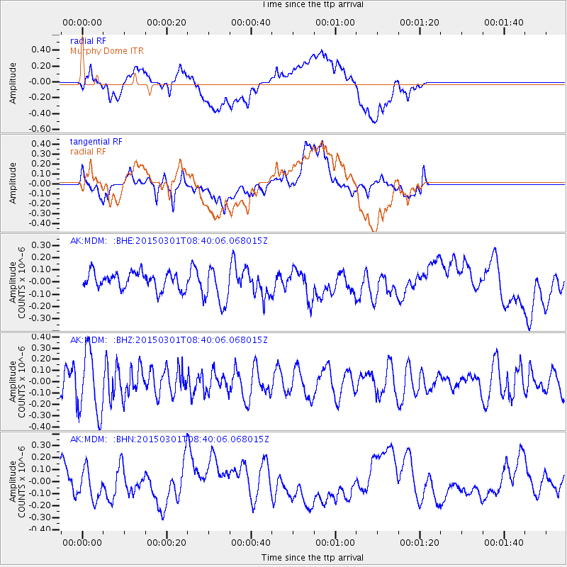
MDM Murphy Dome - Earthquake Result Viewer
*The percent match for this event was below the threshold and hence no stack was calculated.
| Earthquake location: |
Near Coast Of Guatemala |
| Earthquake latitude/longitude: |
13.4/-91.0 |
| Earthquake time(UTC): |
2015/03/01 (060) 08:30:03 GMT |
| Earthquake Depth: |
20 km |
| Earthquake Magnitude: |
5.5 MWW, 5.2 MWB, 5.5 MWC |
| Earthquake Catalog/Contributor: |
NEIC PDE/NEIC COMCAT |
|
| Network: |
AK Alaska Regional Network |
| Station: |
MDM Murphy Dome |
| Lat/Lon: |
64.96 N/148.23 W |
| Elevation: |
634 m |
|
| Distance: |
64.3 deg |
| Az: |
336.605 deg |
| Baz: |
114.81 deg |
| Ray Param: |
$rayparam |
*The percent match for this event was below the threshold and hence was not used in the summary stack. |
|
| Radial Match: |
43.52901 % |
| Radial Bump: |
400 |
| Transverse Match: |
40.98401 % |
| Transverse Bump: |
400 |
| SOD ConfigId: |
7019011 |
| Insert Time: |
2019-04-17 03:47:47.336 +0000 |
| GWidth: |
2.5 |
| Max Bumps: |
400 |
| Tol: |
0.001 |
|
Signal To Noise
| Channel | StoN | STA | LTA |
| AK:MDM: :BHZ:20150301T08:40:06.068015Z | 2.832127 | 2.8402812E-7 | 1.0028791E-7 |
| AK:MDM: :BHN:20150301T08:40:06.068015Z | 1.1359175 | 1.2379725E-7 | 1.08984366E-7 |
| AK:MDM: :BHE:20150301T08:40:06.068015Z | 2.3213303 | 1.5639613E-7 | 6.737349E-8 |
| Arrivals |
| Ps | |
| PpPs | |
| PsPs/PpSs | |


