You are here: Home > Network List > II - Global Seismograph Network (GSN - IRIS/IDA) Stations List
> Station KURK Kurchatov, Kazakhstan > Earthquake Result Viewer
KURK Kurchatov, Kazakhstan - Earthquake Result Viewer

| Earthquake location: |
Mariana Islands Region |
| Earthquake latitude/longitude: |
17.4/147.5 |
| Earthquake time(UTC): |
2000/05/02 (123) 15:03:36 GMT |
| Earthquake Depth: |
55 km |
| Earthquake Magnitude: |
5.8 MB, 5.9 MW, 5.9 MW |
| Earthquake Catalog/Contributor: |
WHDF/NEIC |
|
| Network: |
II Global Seismograph Network (GSN - IRIS/IDA) |
| Station: |
KURK Kurchatov, Kazakhstan |
| Lat/Lon: |
50.72 N/78.62 E |
| Elevation: |
184 m |
|
| Distance: |
63.4 deg |
| Az: |
318.43 deg |
| Baz: |
94.876 deg |
| Ray Param: |
0.0595067 |
| Estimated Moho Depth: |
41.5 km |
| Estimated Crust Vp/Vs: |
1.75 |
| Assumed Crust Vp: |
6.552 km/s |
| Estimated Crust Vs: |
3.755 km/s |
| Estimated Crust Poisson's Ratio: |
0.26 |
|
| Radial Match: |
97.50457 % |
| Radial Bump: |
287 |
| Transverse Match: |
87.4018 % |
| Transverse Bump: |
400 |
| SOD ConfigId: |
3753 |
| Insert Time: |
2010-03-01 22:31:48.506 +0000 |
| GWidth: |
2.5 |
| Max Bumps: |
400 |
| Tol: |
0.001 |
|
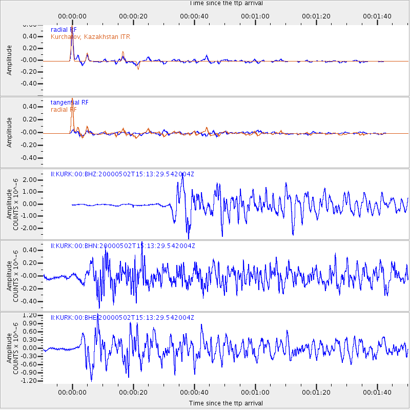
Signal To Noise
| Channel | StoN | STA | LTA |
| II:KURK:00:BHN:20000502T15:13:29.542004Z | 1.5163851 | 6.314801E-8 | 4.164378E-8 |
| II:KURK:00:BHE:20000502T15:13:29.542004Z | 9.349195 | 2.803305E-7 | 2.9984456E-8 |
| II:KURK:00:BHZ:20000502T15:13:29.542004Z | 15.373996 | 7.385624E-7 | 4.8039716E-8 |
| Arrivals |
| Ps | 4.9 SECOND |
| PpPs | 17 SECOND |
| PsPs/PpSs | 22 SECOND |


