You are here: Home > Network List > II - Global Seismograph Network (GSN - IRIS/IDA) Stations List
> Station WRAB Tennant Creek, NT, Australia > Earthquake Result Viewer
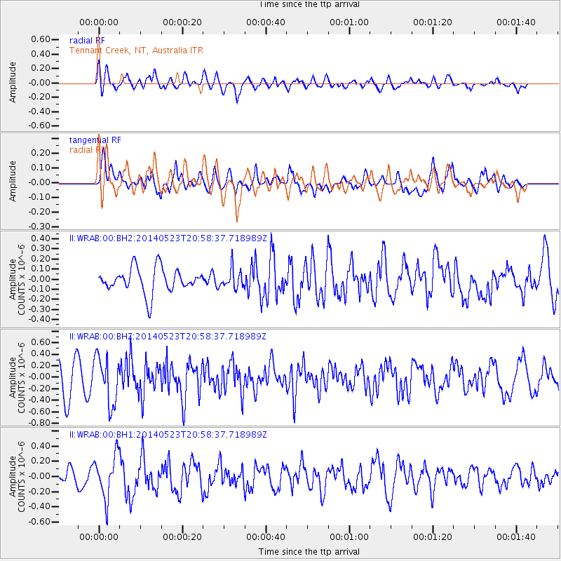
WRAB Tennant Creek, NT, Australia - Earthquake Result Viewer
*The percent match for this event was below the threshold and hence no stack was calculated.
| Earthquake location: |
Myanmar-China Border Region |
| Earthquake latitude/longitude: |
25.0/97.9 |
| Earthquake time(UTC): |
2014/05/23 (143) 20:49:24 GMT |
| Earthquake Depth: |
25 km |
| Earthquake Magnitude: |
5.6 MB |
| Earthquake Catalog/Contributor: |
NEIC PDE/NEIC COMCAT |
|
| Network: |
II Global Seismograph Network (GSN - IRIS/IDA) |
| Station: |
WRAB Tennant Creek, NT, Australia |
| Lat/Lon: |
19.93 S/134.36 E |
| Elevation: |
366 m |
|
| Distance: |
57.0 deg |
| Az: |
138.177 deg |
| Baz: |
319.966 deg |
| Ray Param: |
$rayparam |
*The percent match for this event was below the threshold and hence was not used in the summary stack. |
|
| Radial Match: |
64.225685 % |
| Radial Bump: |
400 |
| Transverse Match: |
67.75603 % |
| Transverse Bump: |
400 |
| SOD ConfigId: |
626651 |
| Insert Time: |
2014-06-06 21:18:18.670 +0000 |
| GWidth: |
2.5 |
| Max Bumps: |
400 |
| Tol: |
0.001 |
|
Signal To Noise
| Channel | StoN | STA | LTA |
| II:WRAB:00:BHZ:20140523T20:58:37.718989Z | 1.6960528 | 4.1416726E-7 | 2.4419478E-7 |
| II:WRAB:00:BH1:20140523T20:58:37.718989Z | 2.2639616 | 2.8521617E-7 | 1.25981E-7 |
| II:WRAB:00:BH2:20140523T20:58:37.718989Z | 0.7902546 | 9.5582244E-8 | 1.209512E-7 |
| Arrivals |
| Ps | |
| PpPs | |
| PsPs/PpSs | |


