You are here: Home > Network List > TA - USArray Transportable Network (new EarthScope stations) Stations List
> Station L04D Klamath Falls, OR, USA > Earthquake Result Viewer
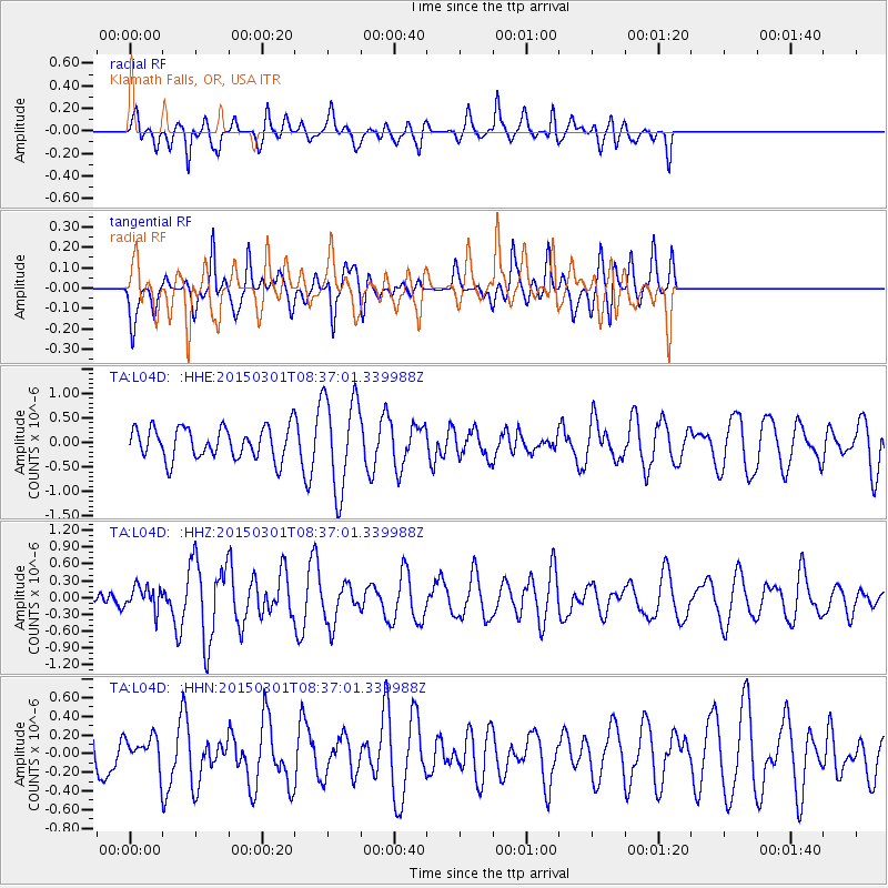
L04D Klamath Falls, OR, USA - Earthquake Result Viewer
*The percent match for this event was below the threshold and hence no stack was calculated.
| Earthquake location: |
Near Coast Of Guatemala |
| Earthquake latitude/longitude: |
13.4/-91.0 |
| Earthquake time(UTC): |
2015/03/01 (060) 08:30:03 GMT |
| Earthquake Depth: |
20 km |
| Earthquake Magnitude: |
5.5 MWW, 5.2 MWB, 5.5 MWC |
| Earthquake Catalog/Contributor: |
NEIC PDE/NEIC COMCAT |
|
| Network: |
TA USArray Transportable Network (new EarthScope stations) |
| Station: |
L04D Klamath Falls, OR, USA |
| Lat/Lon: |
42.22 N/122.30 W |
| Elevation: |
1437 m |
|
| Distance: |
39.5 deg |
| Az: |
322.594 deg |
| Baz: |
127.284 deg |
| Ray Param: |
$rayparam |
*The percent match for this event was below the threshold and hence was not used in the summary stack. |
|
| Radial Match: |
60.333916 % |
| Radial Bump: |
373 |
| Transverse Match: |
45.261078 % |
| Transverse Bump: |
368 |
| SOD ConfigId: |
7019011 |
| Insert Time: |
2019-04-17 03:51:43.617 +0000 |
| GWidth: |
2.5 |
| Max Bumps: |
400 |
| Tol: |
0.001 |
|
Signal To Noise
| Channel | StoN | STA | LTA |
| TA:L04D: :HHZ:20150301T08:37:01.339988Z | 0.51364636 | 2.070701E-7 | 4.0313748E-7 |
| TA:L04D: :HHN:20150301T08:37:01.339988Z | 0.5465717 | 1.6077188E-7 | 2.9414602E-7 |
| TA:L04D: :HHE:20150301T08:37:01.339988Z | 3.1257286 | 9.710399E-7 | 3.1066034E-7 |
| Arrivals |
| Ps | |
| PpPs | |
| PsPs/PpSs | |


