You are here: Home > Network List > UW - Pacific Northwest Regional Seismic Network Stations List
> Station PASS Maple Falls, WA, USA > Earthquake Result Viewer
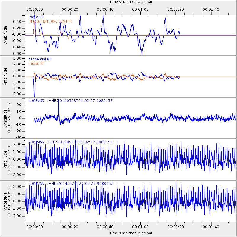
PASS Maple Falls, WA, USA - Earthquake Result Viewer
*The percent match for this event was below the threshold and hence no stack was calculated.
| Earthquake location: |
Myanmar-China Border Region |
| Earthquake latitude/longitude: |
25.0/97.9 |
| Earthquake time(UTC): |
2014/05/23 (143) 20:49:24 GMT |
| Earthquake Depth: |
25 km |
| Earthquake Magnitude: |
5.6 MB |
| Earthquake Catalog/Contributor: |
NEIC PDE/NEIC COMCAT |
|
| Network: |
UW Pacific Northwest Regional Seismic Network |
| Station: |
PASS Maple Falls, WA, USA |
| Lat/Lon: |
49.00 N/122.09 W |
| Elevation: |
174 m |
|
| Distance: |
98.2 deg |
| Az: |
25.296 deg |
| Baz: |
323.927 deg |
| Ray Param: |
$rayparam |
*The percent match for this event was below the threshold and hence was not used in the summary stack. |
|
| Radial Match: |
60.77195 % |
| Radial Bump: |
326 |
| Transverse Match: |
71.42543 % |
| Transverse Bump: |
287 |
| SOD ConfigId: |
626651 |
| Insert Time: |
2014-06-06 21:23:01.800 +0000 |
| GWidth: |
2.5 |
| Max Bumps: |
400 |
| Tol: |
0.001 |
|
Signal To Noise
| Channel | StoN | STA | LTA |
| UW:PASS: :HHZ:20140523T21:02:27.908015Z | 0.5351332 | 9.170261E-7 | 1.7136409E-6 |
| UW:PASS: :HHN:20140523T21:02:27.908015Z | 0.51620513 | 9.607819E-7 | 1.8612403E-6 |
| UW:PASS: :HHE:20140523T21:02:27.908015Z | 0.6133367 | 2.487851E-6 | 4.056257E-6 |
| Arrivals |
| Ps | |
| PpPs | |
| PsPs/PpSs | |


