You are here: Home > Network List > UW - Pacific Northwest Regional Seismic Network Stations List
> Station HOOD Mt Hood Meadows, OR CREST BB SMO > Earthquake Result Viewer
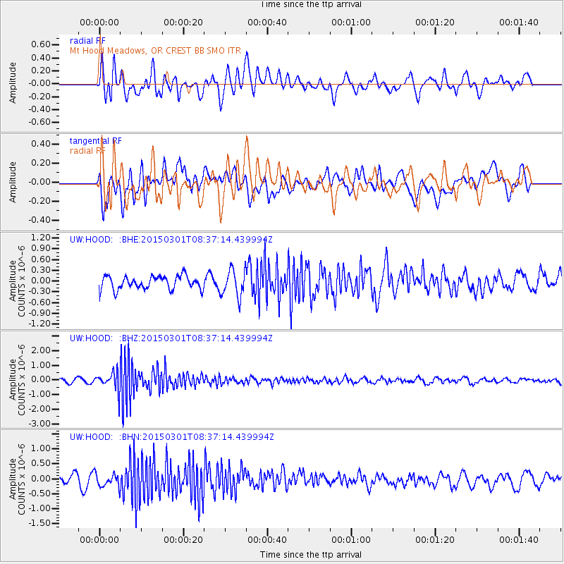
HOOD Mt Hood Meadows, OR CREST BB SMO - Earthquake Result Viewer
*The percent match for this event was below the threshold and hence no stack was calculated.
| Earthquake location: |
Near Coast Of Guatemala |
| Earthquake latitude/longitude: |
13.4/-91.0 |
| Earthquake time(UTC): |
2015/03/01 (060) 08:30:03 GMT |
| Earthquake Depth: |
20 km |
| Earthquake Magnitude: |
5.5 MWW, 5.2 MWB, 5.5 MWC |
| Earthquake Catalog/Contributor: |
NEIC PDE/NEIC COMCAT |
|
| Network: |
UW Pacific Northwest Regional Seismic Network |
| Station: |
HOOD Mt Hood Meadows, OR CREST BB SMO |
| Lat/Lon: |
45.32 N/121.65 W |
| Elevation: |
1520 m |
|
| Distance: |
41.0 deg |
| Az: |
326.781 deg |
| Baz: |
130.93 deg |
| Ray Param: |
$rayparam |
*The percent match for this event was below the threshold and hence was not used in the summary stack. |
|
| Radial Match: |
55.651268 % |
| Radial Bump: |
400 |
| Transverse Match: |
55.083664 % |
| Transverse Bump: |
400 |
| SOD ConfigId: |
7019011 |
| Insert Time: |
2019-04-17 03:52:24.261 +0000 |
| GWidth: |
2.5 |
| Max Bumps: |
400 |
| Tol: |
0.001 |
|
Signal To Noise
| Channel | StoN | STA | LTA |
| UW:HOOD: :BHZ:20150301T08:37:14.439994Z | 5.992002 | 6.299736E-7 | 1.0513575E-7 |
| UW:HOOD: :BHN:20150301T08:37:14.439994Z | 1.2664121 | 2.2384589E-7 | 1.7675596E-7 |
| UW:HOOD: :BHE:20150301T08:37:14.439994Z | 2.0218291 | 3.691919E-7 | 1.826029E-7 |
| Arrivals |
| Ps | |
| PpPs | |
| PsPs/PpSs | |


