You are here: Home > Network List > CN - Canadian National Seismograph Network Stations List
> Station INK INUVIK, NT > Earthquake Result Viewer
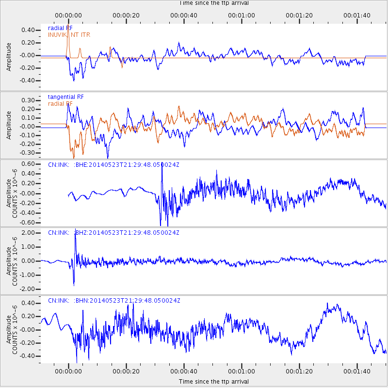
INK INUVIK, NT - Earthquake Result Viewer
*The percent match for this event was below the threshold and hence no stack was calculated.
| Earthquake location: |
Mariana Islands |
| Earthquake latitude/longitude: |
19.0/145.0 |
| Earthquake time(UTC): |
2014/05/23 (143) 21:20:06 GMT |
| Earthquake Depth: |
558 km |
| Earthquake Magnitude: |
5.5 M |
| Earthquake Catalog/Contributor: |
NEIC PDE/NEIC ALERT |
|
| Network: |
CN Canadian National Seismograph Network |
| Station: |
INK INUVIK, NT |
| Lat/Lon: |
68.31 N/133.53 W |
| Elevation: |
44 m |
|
| Distance: |
69.4 deg |
| Az: |
23.133 deg |
| Baz: |
269.348 deg |
| Ray Param: |
$rayparam |
*The percent match for this event was below the threshold and hence was not used in the summary stack. |
|
| Radial Match: |
69.1723 % |
| Radial Bump: |
400 |
| Transverse Match: |
74.159294 % |
| Transverse Bump: |
367 |
| SOD ConfigId: |
626651 |
| Insert Time: |
2014-06-06 21:35:09.894 +0000 |
| GWidth: |
2.5 |
| Max Bumps: |
400 |
| Tol: |
0.001 |
|
Signal To Noise
| Channel | StoN | STA | LTA |
| CN:INK: :BHZ:20140523T21:29:48.050024Z | 7.5068617 | 6.5903197E-7 | 8.779061E-8 |
| CN:INK: :BHN:20140523T21:29:48.050024Z | 1.367096 | 1.4352015E-7 | 1.0498177E-7 |
| CN:INK: :BHE:20140523T21:29:48.050024Z | 4.373624 | 2.969636E-7 | 6.789876E-8 |
| Arrivals |
| Ps | |
| PpPs | |
| PsPs/PpSs | |


