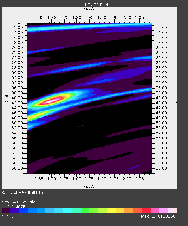
KURK Kurchatov, Kazakhstan - Earthquake Result Viewer
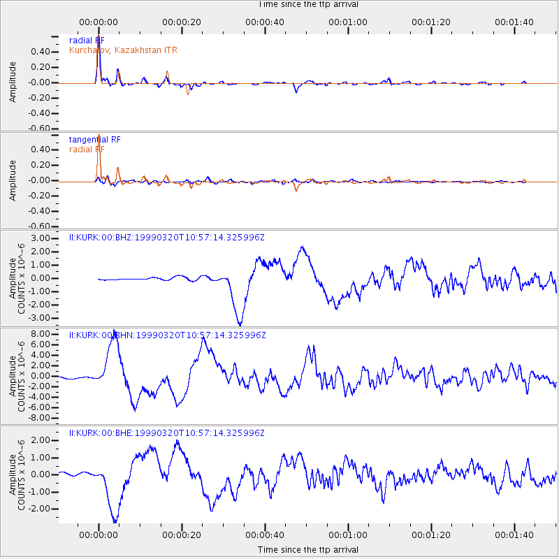
Earthquake location: Andreanof Islands, Aleutian Is.
Earthquake latitude/longitude: 51.6/-177.7
Earthquake time(UTC): 1999/03/20 (079) 10:47:45 GMT
Earthquake Depth: 33 km
Earthquake Magnitude: 6.3 MB, 6.8 MS, 6.9 MW, 6.8 ME
Earthquake Catalog/Contributor: WHDF/NEIC
Network: II Global Seismograph Network (GSN - IRIS/IDA)
Station: KURK Kurchatov, Kazakhstan
Lat/Lon: 50.72 N/78.62 E
Elevation: 184 m
Distance: 59.4 deg
Az: 314.141 deg
Baz: 44.771 deg
Ray Param: 0.062165342
Estimated Moho Depth: 41.25 km
Estimated Crust Vp/Vs: 1.69
Assumed Crust Vp: 6.552 km/s
Estimated Crust Vs: 3.871 km/s
Estimated Crust Poisson's Ratio: 0.23
Radial Match: 97.959145 %
Radial Bump: 310
Transverse Match: 85.78801 %
Transverse Bump: 400
SOD ConfigId: 4480
Insert Time: 2010-03-01 22:32:50.375 +0000
GWidth: 2.5
Max Bumps: 400
Tol: 0.001

Signal To Noise

ChannelStoNSTALTA
II:KURK:00:BHN:19990320T10:57:14.325996Z33.8882684.9897762E-61.4724199E-7
II:KURK:00:BHE:19990320T10:57:14.325996Z14.7921581.5721116E-61.06280076E-7
II:KURK:00:BHZ:19990320T10:57:14.325996Z18.0278131.934419E-61.0730192E-7
Arrivals
Ps4.6 SECOND
PpPs16 SECOND
PsPs/PpSs21 SECOND