You are here: Home > Network List > TA - USArray Transportable Network (new EarthScope stations) Stations List
> Station J01E Myrtle Point, OR, USA > Earthquake Result Viewer
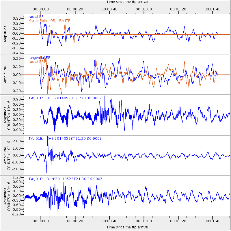
J01E Myrtle Point, OR, USA - Earthquake Result Viewer
*The percent match for this event was below the threshold and hence no stack was calculated.
| Earthquake location: |
Mariana Islands |
| Earthquake latitude/longitude: |
19.0/145.0 |
| Earthquake time(UTC): |
2014/05/23 (143) 21:20:06 GMT |
| Earthquake Depth: |
558 km |
| Earthquake Magnitude: |
5.5 M |
| Earthquake Catalog/Contributor: |
NEIC PDE/NEIC ALERT |
|
| Network: |
TA USArray Transportable Network (new EarthScope stations) |
| Station: |
J01E Myrtle Point, OR, USA |
| Lat/Lon: |
43.16 N/123.93 W |
| Elevation: |
128 m |
|
| Distance: |
78.0 deg |
| Az: |
48.413 deg |
| Baz: |
284.696 deg |
| Ray Param: |
$rayparam |
*The percent match for this event was below the threshold and hence was not used in the summary stack. |
|
| Radial Match: |
54.84281 % |
| Radial Bump: |
400 |
| Transverse Match: |
51.59778 % |
| Transverse Bump: |
400 |
| SOD ConfigId: |
626651 |
| Insert Time: |
2014-06-06 21:47:32.218 +0000 |
| GWidth: |
2.5 |
| Max Bumps: |
400 |
| Tol: |
0.001 |
|
Signal To Noise
| Channel | StoN | STA | LTA |
| TA:J01E: :BHZ:20140523T21:30:36.900Z | 2.7751255 | 8.6613073E-7 | 3.1210504E-7 |
| TA:J01E: :BHN:20140523T21:30:36.900Z | 0.9783199 | 1.9919493E-7 | 2.036092E-7 |
| TA:J01E: :BHE:20140523T21:30:36.900Z | 1.1752145 | 3.3473236E-7 | 2.848266E-7 |
| Arrivals |
| Ps | |
| PpPs | |
| PsPs/PpSs | |


