You are here: Home > Network List > TA - USArray Transportable Network (new EarthScope stations) Stations List
> Station J04D Umpqua National Forest, Toketee, OR, USA > Earthquake Result Viewer
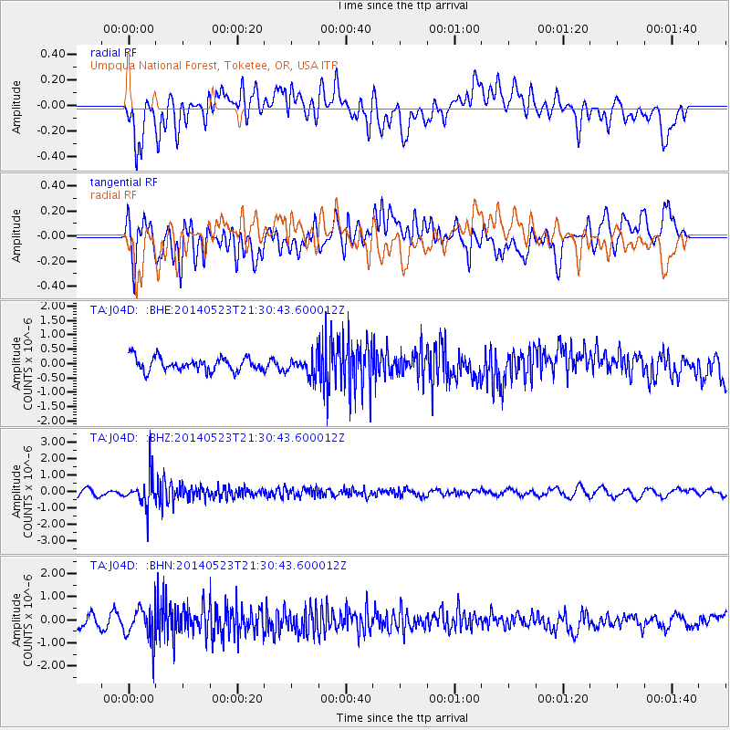
J04D Umpqua National Forest, Toketee, OR, USA - Earthquake Result Viewer
*The percent match for this event was below the threshold and hence no stack was calculated.
| Earthquake location: |
Mariana Islands |
| Earthquake latitude/longitude: |
19.0/145.0 |
| Earthquake time(UTC): |
2014/05/23 (143) 21:20:06 GMT |
| Earthquake Depth: |
558 km |
| Earthquake Magnitude: |
5.5 M |
| Earthquake Catalog/Contributor: |
NEIC PDE/NEIC ALERT |
|
| Network: |
TA USArray Transportable Network (new EarthScope stations) |
| Station: |
J04D Umpqua National Forest, Toketee, OR, USA |
| Lat/Lon: |
43.24 N/122.11 W |
| Elevation: |
1948 m |
|
| Distance: |
79.3 deg |
| Az: |
47.978 deg |
| Baz: |
285.853 deg |
| Ray Param: |
$rayparam |
*The percent match for this event was below the threshold and hence was not used in the summary stack. |
|
| Radial Match: |
62.144516 % |
| Radial Bump: |
400 |
| Transverse Match: |
64.70776 % |
| Transverse Bump: |
400 |
| SOD ConfigId: |
626651 |
| Insert Time: |
2014-06-06 21:47:32.742 +0000 |
| GWidth: |
2.5 |
| Max Bumps: |
400 |
| Tol: |
0.001 |
|
Signal To Noise
| Channel | StoN | STA | LTA |
| TA:J04D: :BHZ:20140523T21:30:43.600012Z | 3.7034962 | 9.736328E-7 | 2.6289558E-7 |
| TA:J04D: :BHN:20140523T21:30:43.600012Z | 1.7473699 | 7.271256E-7 | 4.1612574E-7 |
| TA:J04D: :BHE:20140523T21:30:43.600012Z | 1.4733552 | 3.4487363E-7 | 2.3407365E-7 |
| Arrivals |
| Ps | |
| PpPs | |
| PsPs/PpSs | |


