You are here: Home > Network List > UW - Pacific Northwest Regional Seismic Network Stations List
> Station PASS Maple Falls, WA, USA > Earthquake Result Viewer
PASS Maple Falls, WA, USA - Earthquake Result Viewer
| Earthquake location: |
Mariana Islands |
| Earthquake latitude/longitude: |
19.0/145.0 |
| Earthquake time(UTC): |
2014/05/23 (143) 21:20:06 GMT |
| Earthquake Depth: |
558 km |
| Earthquake Magnitude: |
5.5 M |
| Earthquake Catalog/Contributor: |
NEIC PDE/NEIC ALERT |
|
| Network: |
UW Pacific Northwest Regional Seismic Network |
| Station: |
PASS Maple Falls, WA, USA |
| Lat/Lon: |
49.00 N/122.09 W |
| Elevation: |
174 m |
|
| Distance: |
77.8 deg |
| Az: |
42.304 deg |
| Baz: |
284.739 deg |
| Ray Param: |
0.048373424 |
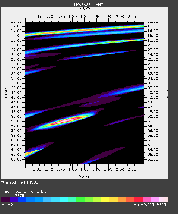
| Estimated Moho Depth: |
51.75 km |
| Estimated Crust Vp/Vs: |
1.76 |
| Assumed Crust Vp: |
6.566 km/s |
| Estimated Crust Vs: |
3.736 km/s |
| Estimated Crust Poisson's Ratio: |
0.26 |
|
| Radial Match: |
94.14365 % |
| Radial Bump: |
88 |
| Transverse Match: |
99.22553 % |
| Transverse Bump: |
34 |
| SOD ConfigId: |
626651 |
| Insert Time: |
2014-06-06 21:54:09.245 +0000 |
| GWidth: |
2.5 |
| Max Bumps: |
400 |
| Tol: |
0.001 |
|
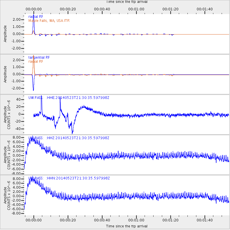
Signal To Noise
| Channel | StoN | STA | LTA |
| UW:PASS: :HHZ:20140523T21:30:35.597998Z | 1.2225438 | 9.2670925E-6 | 7.580172E-6 |
| UW:PASS: :HHN:20140523T21:30:35.597998Z | 1.2330574 | 1.00155885E-5 | 8.122565E-6 |
| UW:PASS: :HHE:20140523T21:30:35.597998Z | 1.5553819 | 2.5607975E-5 | 1.6464108E-5 |
| Arrivals |
| Ps | 6.2 SECOND |
| PpPs | 21 SECOND |
| PsPs/PpSs | 27 SECOND |


