You are here: Home > Network List > AK - Alaska Regional Network Stations List
> Station BARN Barnard Glacier, AK, USA > Earthquake Result Viewer
BARN Barnard Glacier, AK, USA - Earthquake Result Viewer
| Earthquake location: |
Aegean Sea |
| Earthquake latitude/longitude: |
40.3/25.5 |
| Earthquake time(UTC): |
2014/05/24 (144) 09:25:03 GMT |
| Earthquake Depth: |
10 km |
| Earthquake Magnitude: |
6.4 MWP, 6.4 M |
| Earthquake Catalog/Contributor: |
NEIC PDE/NEIC ALERT |
|
| Network: |
AK Alaska Regional Network |
| Station: |
BARN Barnard Glacier, AK, USA |
| Lat/Lon: |
61.06 N/141.66 W |
| Elevation: |
1689 m |
|
| Distance: |
78.4 deg |
| Az: |
353.644 deg |
| Baz: |
10.023 deg |
| Ray Param: |
0.049644426 |
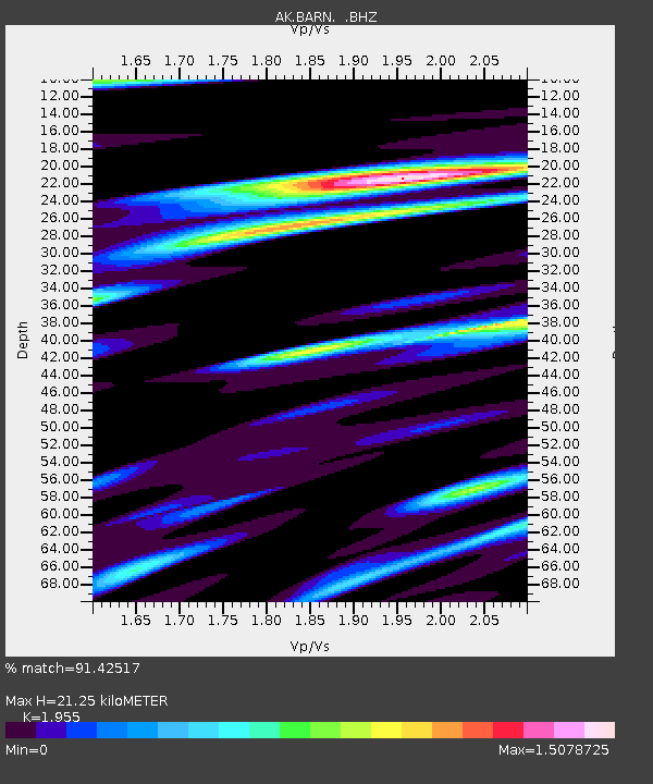
| Estimated Moho Depth: |
21.25 km |
| Estimated Crust Vp/Vs: |
1.96 |
| Assumed Crust Vp: |
6.566 km/s |
| Estimated Crust Vs: |
3.359 km/s |
| Estimated Crust Poisson's Ratio: |
0.32 |
|
| Radial Match: |
91.42517 % |
| Radial Bump: |
400 |
| Transverse Match: |
83.2887 % |
| Transverse Bump: |
400 |
| SOD ConfigId: |
626651 |
| Insert Time: |
2014-06-07 09:33:46.986 +0000 |
| GWidth: |
2.5 |
| Max Bumps: |
400 |
| Tol: |
0.001 |
|

Signal To Noise
| Channel | StoN | STA | LTA |
| AK:BARN: :BHZ:20140524T09:36:33.087976Z | 2.3283658 | 2.1020976E-7 | 9.028211E-8 |
| AK:BARN: :BHN:20140524T09:36:33.087976Z | 1.8901397 | 1.5568592E-7 | 8.2367414E-8 |
| AK:BARN: :BHE:20140524T09:36:33.087976Z | 2.3215787 | 1.1942421E-7 | 5.144095E-8 |
| Arrivals |
| Ps | 3.2 SECOND |
| PpPs | 9.3 SECOND |
| PsPs/PpSs | 12 SECOND |


