You are here: Home > Network List > N4 - Central and EAstern US Network Stations List
> Station P46A Rosedale, IN, USA > Earthquake Result Viewer
P46A Rosedale, IN, USA - Earthquake Result Viewer
| Earthquake location: |
Aegean Sea |
| Earthquake latitude/longitude: |
40.3/25.5 |
| Earthquake time(UTC): |
2014/05/24 (144) 09:25:03 GMT |
| Earthquake Depth: |
10 km |
| Earthquake Magnitude: |
6.4 MWP, 6.4 M |
| Earthquake Catalog/Contributor: |
NEIC PDE/NEIC ALERT |
|
| Network: |
N4 Central and EAstern US Network |
| Station: |
P46A Rosedale, IN, USA |
| Lat/Lon: |
39.62 N/87.21 W |
| Elevation: |
194 m |
|
| Distance: |
79.5 deg |
| Az: |
313.543 deg |
| Baz: |
45.856 deg |
| Ray Param: |
0.048898697 |
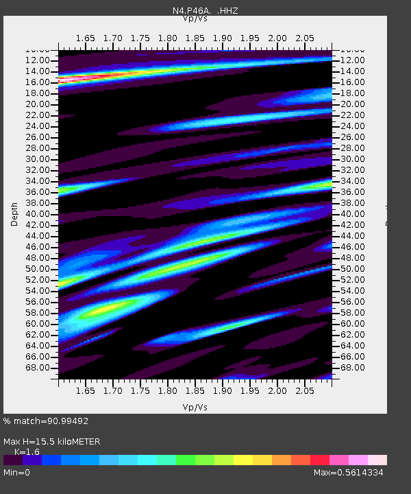
| Estimated Moho Depth: |
15.5 km |
| Estimated Crust Vp/Vs: |
1.60 |
| Assumed Crust Vp: |
6.444 km/s |
| Estimated Crust Vs: |
4.027 km/s |
| Estimated Crust Poisson's Ratio: |
0.18 |
|
| Radial Match: |
90.99492 % |
| Radial Bump: |
400 |
| Transverse Match: |
75.728355 % |
| Transverse Bump: |
400 |
| SOD ConfigId: |
626651 |
| Insert Time: |
2014-06-07 09:54:52.749 +0000 |
| GWidth: |
2.5 |
| Max Bumps: |
400 |
| Tol: |
0.001 |
|

Signal To Noise
| Channel | StoN | STA | LTA |
| N4:P46A: :HHZ:20140524T09:36:39.069971Z | 4.891142 | 3.970233E-7 | 8.1171905E-8 |
| N4:P46A: :HHN:20140524T09:36:39.069971Z | 1.1757169 | 1.14106456E-7 | 9.705267E-8 |
| N4:P46A: :HHE:20140524T09:36:39.069971Z | 2.3382769 | 1.7447353E-7 | 7.461628E-8 |
| Arrivals |
| Ps | 1.5 SECOND |
| PpPs | 6.1 SECOND |
| PsPs/PpSs | 7.5 SECOND |


