You are here: Home > Network List > CI - Caltech Regional Seismic Network Stations List
> Station VCS Vincent SCE, California, USA > Earthquake Result Viewer
VCS Vincent SCE, California, USA - Earthquake Result Viewer
| Earthquake location: |
Mariana Islands |
| Earthquake latitude/longitude: |
16.0/145.9 |
| Earthquake time(UTC): |
2005/02/05 (036) 03:34:25 GMT |
| Earthquake Depth: |
143 km |
| Earthquake Magnitude: |
6.3 MB, 6.6 MW, 6.5 MW |
| Earthquake Catalog/Contributor: |
WHDF/NEIC |
|
| Network: |
CI Caltech Regional Seismic Network |
| Station: |
VCS Vincent SCE, California, USA |
| Lat/Lon: |
34.48 N/118.11 W |
| Elevation: |
962 m |
|
| Distance: |
85.9 deg |
| Az: |
55.445 deg |
| Baz: |
286.5 deg |
| Ray Param: |
0.044104926 |
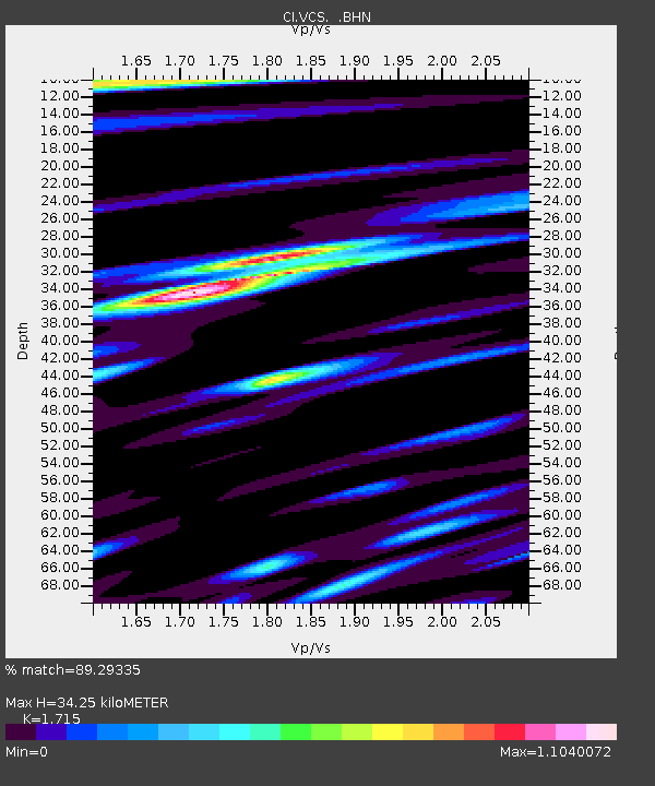
| Estimated Moho Depth: |
34.25 km |
| Estimated Crust Vp/Vs: |
1.72 |
| Assumed Crust Vp: |
6.1 km/s |
| Estimated Crust Vs: |
3.557 km/s |
| Estimated Crust Poisson's Ratio: |
0.24 |
|
| Radial Match: |
89.29335 % |
| Radial Bump: |
400 |
| Transverse Match: |
90.243355 % |
| Transverse Bump: |
400 |
| SOD ConfigId: |
5233 |
| Insert Time: |
2010-02-25 21:05:59.912 +0000 |
| GWidth: |
2.5 |
| Max Bumps: |
400 |
| Tol: |
0.001 |
|

Signal To Noise
| Channel | StoN | STA | LTA |
| CI:VCS: :BHN:20050205T03:46:18.51302Z | 1.6639719 | 9.778145E-8 | 5.876388E-8 |
| CI:VCS: :BHE:20050205T03:46:18.51302Z | 2.0930984 | 1.6164311E-7 | 7.7226716E-8 |
| CI:VCS: :BHZ:20050205T03:46:18.51302Z | 5.1187787 | 5.362689E-7 | 1.0476501E-7 |
| Arrivals |
| Ps | 4.1 SECOND |
| PpPs | 15 SECOND |
| PsPs/PpSs | 19 SECOND |


