You are here: Home > Network List > TA - USArray Transportable Network (new EarthScope stations) Stations List
> Station F63A Nahmakanta, Browneville, ME, USA > Earthquake Result Viewer
F63A Nahmakanta, Browneville, ME, USA - Earthquake Result Viewer
| Earthquake location: |
Aegean Sea |
| Earthquake latitude/longitude: |
40.3/25.5 |
| Earthquake time(UTC): |
2014/05/24 (144) 09:25:03 GMT |
| Earthquake Depth: |
10 km |
| Earthquake Magnitude: |
6.4 MWP, 6.4 M |
| Earthquake Catalog/Contributor: |
NEIC PDE/NEIC ALERT |
|
| Network: |
TA USArray Transportable Network (new EarthScope stations) |
| Station: |
F63A Nahmakanta, Browneville, ME, USA |
| Lat/Lon: |
45.70 N/69.10 W |
| Elevation: |
386 m |
|
| Distance: |
65.3 deg |
| Az: |
309.768 deg |
| Baz: |
57.004 deg |
| Ray Param: |
0.05833324 |
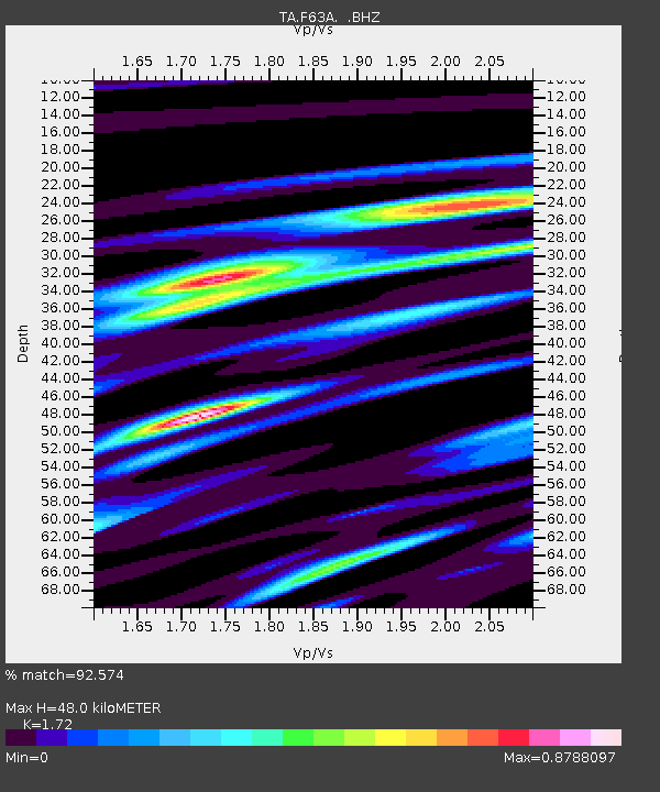
| Estimated Moho Depth: |
48.0 km |
| Estimated Crust Vp/Vs: |
1.72 |
| Assumed Crust Vp: |
6.419 km/s |
| Estimated Crust Vs: |
3.732 km/s |
| Estimated Crust Poisson's Ratio: |
0.24 |
|
| Radial Match: |
92.574 % |
| Radial Bump: |
363 |
| Transverse Match: |
80.468834 % |
| Transverse Bump: |
400 |
| SOD ConfigId: |
626651 |
| Insert Time: |
2014-06-07 10:07:11.510 +0000 |
| GWidth: |
2.5 |
| Max Bumps: |
400 |
| Tol: |
0.001 |
|

Signal To Noise
| Channel | StoN | STA | LTA |
| TA:F63A: :BHZ:20140524T09:35:14.725Z | 4.505646 | 5.6650356E-7 | 1.2573192E-7 |
| TA:F63A: :BHN:20140524T09:35:14.725Z | 1.1308329 | 1.4296911E-7 | 1.2642816E-7 |
| TA:F63A: :BHE:20140524T09:35:14.725Z | 1.9649222 | 2.502382E-7 | 1.2735273E-7 |
| Arrivals |
| Ps | 5.6 SECOND |
| PpPs | 19 SECOND |
| PsPs/PpSs | 25 SECOND |


