You are here: Home > Network List > TA - USArray Transportable Network (new EarthScope stations) Stations List
> Station G53A Haliburton, ON, CAN > Earthquake Result Viewer
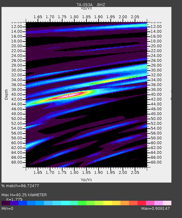
G53A Haliburton, ON, CAN - Earthquake Result Viewer
| Earthquake location: |
Aegean Sea |
| Earthquake latitude/longitude: |
40.3/25.5 |
| Earthquake time(UTC): |
2014/05/24 (144) 09:25:03 GMT |
| Earthquake Depth: |
10 km |
| Earthquake Magnitude: |
6.4 MWP, 6.4 M |
| Earthquake Catalog/Contributor: |
NEIC PDE/NEIC ALERT |
|
| Network: |
TA USArray Transportable Network (new EarthScope stations) |
| Station: |
G53A Haliburton, ON, CAN |
| Lat/Lon: |
45.12 N/78.62 W |
| Elevation: |
333 m |
|
| Distance: |
71.1 deg |
| Az: |
313.471 deg |
| Baz: |
51.613 deg |
| Ray Param: |
0.054525357 |
| Estimated Moho Depth: |
40.25 km |
| Estimated Crust Vp/Vs: |
1.77 |
| Assumed Crust Vp: |
6.577 km/s |
| Estimated Crust Vs: |
3.705 km/s |
| Estimated Crust Poisson's Ratio: |
0.27 |
|
| Radial Match: |
96.72477 % |
| Radial Bump: |
303 |
| Transverse Match: |
87.27628 % |
| Transverse Bump: |
400 |
| SOD ConfigId: |
626651 |
| Insert Time: |
2014-06-07 10:07:29.969 +0000 |
| GWidth: |
2.5 |
| Max Bumps: |
400 |
| Tol: |
0.001 |
|

Signal To Noise
| Channel | StoN | STA | LTA |
| TA:G53A: :BHZ:20140524T09:35:50.899988Z | 5.3216953 | 5.6821034E-7 | 1.06772426E-7 |
| TA:G53A: :BHN:20140524T09:35:50.899988Z | 3.5062578 | 2.0594874E-7 | 5.8737477E-8 |
| TA:G53A: :BHE:20140524T09:35:50.899988Z | 2.0936391 | 1.3999285E-7 | 6.6865795E-8 |
| Arrivals |
| Ps | 4.9 SECOND |
| PpPs | 16 SECOND |
| PsPs/PpSs | 21 SECOND |


