You are here: Home > Network List > TA - USArray Transportable Network (new EarthScope stations) Stations List
> Station H61A Lyndonville, VT, USA > Earthquake Result Viewer
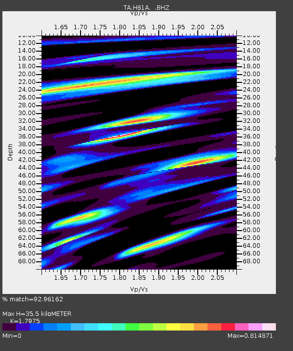
H61A Lyndonville, VT, USA - Earthquake Result Viewer
| Earthquake location: |
Aegean Sea |
| Earthquake latitude/longitude: |
40.3/25.5 |
| Earthquake time(UTC): |
2014/05/24 (144) 09:25:03 GMT |
| Earthquake Depth: |
10 km |
| Earthquake Magnitude: |
6.4 MWP, 6.4 M |
| Earthquake Catalog/Contributor: |
NEIC PDE/NEIC ALERT |
|
| Network: |
TA USArray Transportable Network (new EarthScope stations) |
| Station: |
H61A Lyndonville, VT, USA |
| Lat/Lon: |
44.53 N/71.93 W |
| Elevation: |
462 m |
|
| Distance: |
67.7 deg |
| Az: |
309.929 deg |
| Baz: |
55.074 deg |
| Ray Param: |
0.056814376 |
| Estimated Moho Depth: |
35.5 km |
| Estimated Crust Vp/Vs: |
1.80 |
| Assumed Crust Vp: |
6.419 km/s |
| Estimated Crust Vs: |
3.571 km/s |
| Estimated Crust Poisson's Ratio: |
0.28 |
|
| Radial Match: |
92.96162 % |
| Radial Bump: |
400 |
| Transverse Match: |
87.31731 % |
| Transverse Bump: |
400 |
| SOD ConfigId: |
626651 |
| Insert Time: |
2014-06-07 10:08:53.403 +0000 |
| GWidth: |
2.5 |
| Max Bumps: |
400 |
| Tol: |
0.001 |
|

Signal To Noise
| Channel | StoN | STA | LTA |
| TA:H61A: :BHZ:20140524T09:35:29.475Z | 2.094996 | 3.7157398E-7 | 1.7736261E-7 |
| TA:H61A: :BHN:20140524T09:35:29.475Z | 1.3821012 | 1.3563496E-7 | 9.813678E-8 |
| TA:H61A: :BHE:20140524T09:35:29.475Z | 1.6708617 | 2.1995406E-7 | 1.3164109E-7 |
| Arrivals |
| Ps | 4.6 SECOND |
| PpPs | 15 SECOND |
| PsPs/PpSs | 19 SECOND |


