You are here: Home > Network List > TA - USArray Transportable Network (new EarthScope stations) Stations List
> Station H64A Troy, ME, USA > Earthquake Result Viewer
H64A Troy, ME, USA - Earthquake Result Viewer
| Earthquake location: |
Aegean Sea |
| Earthquake latitude/longitude: |
40.3/25.5 |
| Earthquake time(UTC): |
2014/05/24 (144) 09:25:03 GMT |
| Earthquake Depth: |
10 km |
| Earthquake Magnitude: |
6.4 MWP, 6.4 M |
| Earthquake Catalog/Contributor: |
NEIC PDE/NEIC ALERT |
|
| Network: |
TA USArray Transportable Network (new EarthScope stations) |
| Station: |
H64A Troy, ME, USA |
| Lat/Lon: |
44.64 N/69.22 W |
| Elevation: |
158 m |
|
| Distance: |
66.0 deg |
| Az: |
308.843 deg |
| Baz: |
56.54 deg |
| Ray Param: |
0.057905614 |
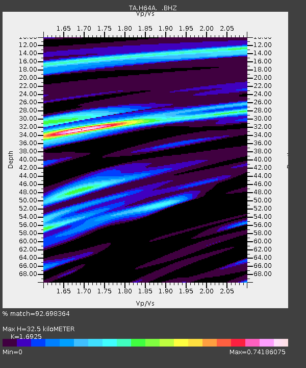
| Estimated Moho Depth: |
32.5 km |
| Estimated Crust Vp/Vs: |
1.69 |
| Assumed Crust Vp: |
6.419 km/s |
| Estimated Crust Vs: |
3.793 km/s |
| Estimated Crust Poisson's Ratio: |
0.23 |
|
| Radial Match: |
92.698364 % |
| Radial Bump: |
344 |
| Transverse Match: |
78.99325 % |
| Transverse Bump: |
400 |
| SOD ConfigId: |
626651 |
| Insert Time: |
2014-06-07 10:09:05.768 +0000 |
| GWidth: |
2.5 |
| Max Bumps: |
400 |
| Tol: |
0.001 |
|

Signal To Noise
| Channel | StoN | STA | LTA |
| TA:H64A: :BHZ:20140524T09:35:18.925012Z | 2.6252105 | 4.38142E-7 | 1.6689785E-7 |
| TA:H64A: :BHN:20140524T09:35:18.925012Z | 0.9783419 | 1.2528305E-7 | 1.2805653E-7 |
| TA:H64A: :BHE:20140524T09:35:18.925012Z | 1.7461773 | 1.8214642E-7 | 1.04311525E-7 |
| Arrivals |
| Ps | 3.7 SECOND |
| PpPs | 13 SECOND |
| PsPs/PpSs | 17 SECOND |


