You are here: Home > Network List > TA - USArray Transportable Network (new EarthScope stations) Stations List
> Station H65A Eastbrook, ME, USA > Earthquake Result Viewer
H65A Eastbrook, ME, USA - Earthquake Result Viewer
| Earthquake location: |
Aegean Sea |
| Earthquake latitude/longitude: |
40.3/25.5 |
| Earthquake time(UTC): |
2014/05/24 (144) 09:25:03 GMT |
| Earthquake Depth: |
10 km |
| Earthquake Magnitude: |
6.4 MWP, 6.4 M |
| Earthquake Catalog/Contributor: |
NEIC PDE/NEIC ALERT |
|
| Network: |
TA USArray Transportable Network (new EarthScope stations) |
| Station: |
H65A Eastbrook, ME, USA |
| Lat/Lon: |
44.70 N/68.25 W |
| Elevation: |
98 m |
|
| Distance: |
65.4 deg |
| Az: |
308.477 deg |
| Baz: |
57.071 deg |
| Ray Param: |
0.058306936 |
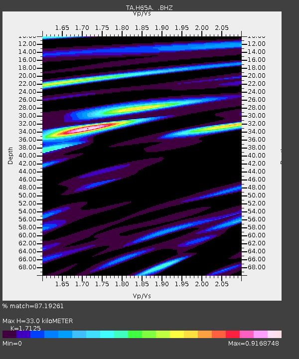
| Estimated Moho Depth: |
33.0 km |
| Estimated Crust Vp/Vs: |
1.71 |
| Assumed Crust Vp: |
6.419 km/s |
| Estimated Crust Vs: |
3.748 km/s |
| Estimated Crust Poisson's Ratio: |
0.24 |
|
| Radial Match: |
87.19261 % |
| Radial Bump: |
364 |
| Transverse Match: |
82.81315 % |
| Transverse Bump: |
400 |
| SOD ConfigId: |
626651 |
| Insert Time: |
2014-06-07 10:09:09.141 +0000 |
| GWidth: |
2.5 |
| Max Bumps: |
400 |
| Tol: |
0.001 |
|

Signal To Noise
| Channel | StoN | STA | LTA |
| TA:H65A: :BHZ:20140524T09:35:15.000024Z | 2.0617418 | 3.7424556E-7 | 1.8151913E-7 |
| TA:H65A: :BHN:20140524T09:35:15.000024Z | 2.0622094 | 2.0604912E-7 | 9.991668E-8 |
| TA:H65A: :BHE:20140524T09:35:15.000024Z | 1.5536989 | 2.381439E-7 | 1.5327545E-7 |
| Arrivals |
| Ps | 3.8 SECOND |
| PpPs | 13 SECOND |
| PsPs/PpSs | 17 SECOND |


