You are here: Home > Network List > TA - USArray Transportable Network (new EarthScope stations) Stations List
> Station I49A Point Hope, MI, USA > Earthquake Result Viewer
I49A Point Hope, MI, USA - Earthquake Result Viewer

| Earthquake location: |
Aegean Sea |
| Earthquake latitude/longitude: |
40.3/25.5 |
| Earthquake time(UTC): |
2014/05/24 (144) 09:25:03 GMT |
| Earthquake Depth: |
10 km |
| Earthquake Magnitude: |
6.4 MWP, 6.4 M |
| Earthquake Catalog/Contributor: |
NEIC PDE/NEIC ALERT |
|
| Network: |
TA USArray Transportable Network (new EarthScope stations) |
| Station: |
I49A Point Hope, MI, USA |
| Lat/Lon: |
43.94 N/82.82 W |
| Elevation: |
217 m |
|
| Distance: |
74.2 deg |
| Az: |
314.529 deg |
| Baz: |
48.992 deg |
| Ray Param: |
0.05249726 |
| Estimated Moho Depth: |
39.25 km |
| Estimated Crust Vp/Vs: |
1.74 |
| Assumed Crust Vp: |
6.483 km/s |
| Estimated Crust Vs: |
3.731 km/s |
| Estimated Crust Poisson's Ratio: |
0.25 |
|
| Radial Match: |
91.46478 % |
| Radial Bump: |
382 |
| Transverse Match: |
76.177475 % |
| Transverse Bump: |
400 |
| SOD ConfigId: |
626651 |
| Insert Time: |
2014-06-07 10:09:39.123 +0000 |
| GWidth: |
2.5 |
| Max Bumps: |
400 |
| Tol: |
0.001 |
|
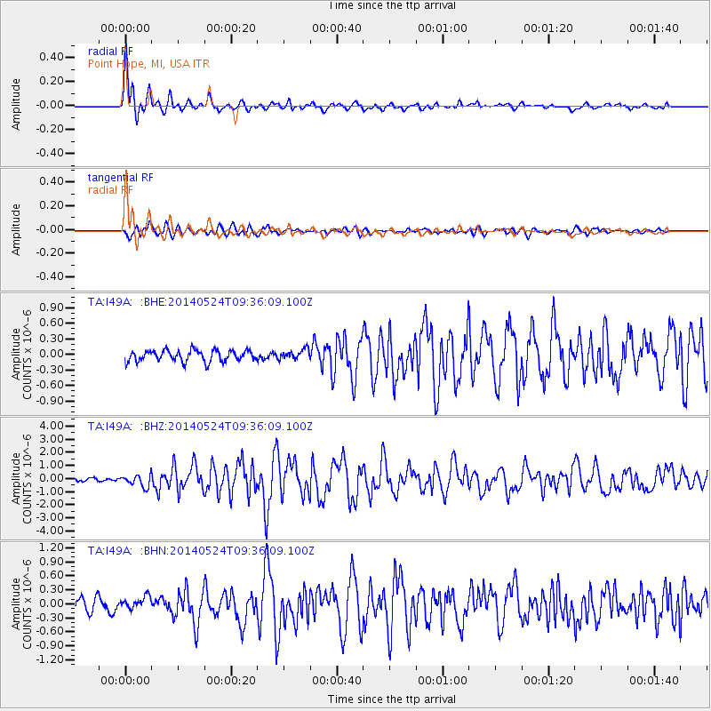
Signal To Noise
| Channel | StoN | STA | LTA |
| TA:I49A: :BHZ:20140524T09:36:09.100Z | 3.817756 | 4.4220536E-7 | 1.1582861E-7 |
| TA:I49A: :BHN:20140524T09:36:09.100Z | 1.0603704 | 1.3871288E-7 | 1.308155E-7 |
| TA:I49A: :BHE:20140524T09:36:09.100Z | 0.91724473 | 9.904293E-8 | 1.07978735E-7 |
| Arrivals |
| Ps | 4.6 SECOND |
| PpPs | 16 SECOND |
| PsPs/PpSs | 21 SECOND |


