You are here: Home > Network List > TA - USArray Transportable Network (new EarthScope stations) Stations List
> Station I58A Old Forge, NY, USA > Earthquake Result Viewer
I58A Old Forge, NY, USA - Earthquake Result Viewer
| Earthquake location: |
Aegean Sea |
| Earthquake latitude/longitude: |
40.3/25.5 |
| Earthquake time(UTC): |
2014/05/24 (144) 09:25:03 GMT |
| Earthquake Depth: |
10 km |
| Earthquake Magnitude: |
6.4 MWP, 6.4 M |
| Earthquake Catalog/Contributor: |
NEIC PDE/NEIC ALERT |
|
| Network: |
TA USArray Transportable Network (new EarthScope stations) |
| Station: |
I58A Old Forge, NY, USA |
| Lat/Lon: |
43.69 N/74.97 W |
| Elevation: |
599 m |
|
| Distance: |
69.9 deg |
| Az: |
310.575 deg |
| Baz: |
53.194 deg |
| Ray Param: |
0.055321075 |
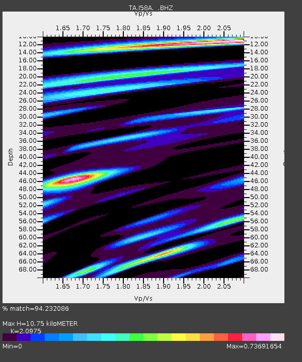
| Estimated Moho Depth: |
10.75 km |
| Estimated Crust Vp/Vs: |
2.10 |
| Assumed Crust Vp: |
6.419 km/s |
| Estimated Crust Vs: |
3.06 km/s |
| Estimated Crust Poisson's Ratio: |
0.35 |
|
| Radial Match: |
94.232086 % |
| Radial Bump: |
400 |
| Transverse Match: |
77.677795 % |
| Transverse Bump: |
400 |
| SOD ConfigId: |
626651 |
| Insert Time: |
2014-06-07 10:09:55.563 +0000 |
| GWidth: |
2.5 |
| Max Bumps: |
400 |
| Tol: |
0.001 |
|

Signal To Noise
| Channel | StoN | STA | LTA |
| TA:I58A: :BHZ:20140524T09:35:43.600Z | 4.708354 | 6.1277524E-7 | 1.3014639E-7 |
| TA:I58A: :BHN:20140524T09:35:43.600Z | 2.9694812 | 3.1873284E-7 | 1.07336206E-7 |
| TA:I58A: :BHE:20140524T09:35:43.600Z | 2.1442883 | 2.4893913E-7 | 1.1609406E-7 |
| Arrivals |
| Ps | 1.9 SECOND |
| PpPs | 5.0 SECOND |
| PsPs/PpSs | 6.9 SECOND |


