You are here: Home > Network List > TA - USArray Transportable Network (new EarthScope stations) Stations List
> Station J57A Williamstown, NY, USA > Earthquake Result Viewer
J57A Williamstown, NY, USA - Earthquake Result Viewer
| Earthquake location: |
Aegean Sea |
| Earthquake latitude/longitude: |
40.3/25.5 |
| Earthquake time(UTC): |
2014/05/24 (144) 09:25:03 GMT |
| Earthquake Depth: |
10 km |
| Earthquake Magnitude: |
6.4 MWP, 6.4 M |
| Earthquake Catalog/Contributor: |
NEIC PDE/NEIC ALERT |
|
| Network: |
TA USArray Transportable Network (new EarthScope stations) |
| Station: |
J57A Williamstown, NY, USA |
| Lat/Lon: |
43.41 N/76.00 W |
| Elevation: |
191 m |
|
| Distance: |
70.7 deg |
| Az: |
310.815 deg |
| Baz: |
52.572 deg |
| Ray Param: |
0.054815516 |
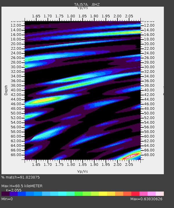
| Estimated Moho Depth: |
68.5 km |
| Estimated Crust Vp/Vs: |
2.06 |
| Assumed Crust Vp: |
6.419 km/s |
| Estimated Crust Vs: |
3.124 km/s |
| Estimated Crust Poisson's Ratio: |
0.34 |
|
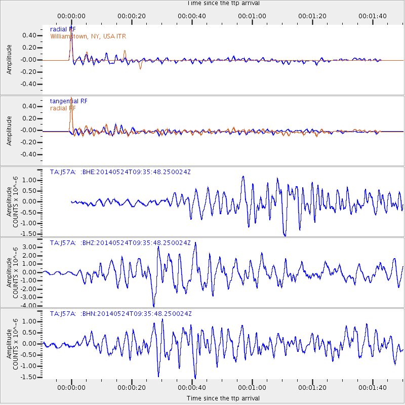
| Radial Match: |
91.823875 % |
| Radial Bump: |
400 |
| Transverse Match: |
80.058754 % |
| Transverse Bump: |
400 |
| SOD ConfigId: |
626651 |
| Insert Time: |
2014-06-07 10:11:42.470 +0000 |
| GWidth: |
2.5 |
| Max Bumps: |
400 |
| Tol: |
0.001 |
|
Signal To Noise
| Channel | StoN | STA | LTA |
| TA:J57A: :BHZ:20140524T09:35:48.250024Z | 5.022387 | 4.885481E-7 | 9.727409E-8 |
| TA:J57A: :BHN:20140524T09:35:48.250024Z | 2.5552778 | 1.569874E-7 | 6.143653E-8 |
| TA:J57A: :BHE:20140524T09:35:48.250024Z | 2.243669 | 2.0228357E-7 | 9.015749E-8 |
| Arrivals |
| Ps | 12 SECOND |
| PpPs | 32 SECOND |
| PsPs/PpSs | 43 SECOND |


