You are here: Home > Network List > TA - USArray Transportable Network (new EarthScope stations) Stations List
> Station J61A Chester, VT, USA > Earthquake Result Viewer
J61A Chester, VT, USA - Earthquake Result Viewer
| Earthquake location: |
Aegean Sea |
| Earthquake latitude/longitude: |
40.3/25.5 |
| Earthquake time(UTC): |
2014/05/24 (144) 09:25:03 GMT |
| Earthquake Depth: |
10 km |
| Earthquake Magnitude: |
6.4 MWP, 6.4 M |
| Earthquake Catalog/Contributor: |
NEIC PDE/NEIC ALERT |
|
| Network: |
TA USArray Transportable Network (new EarthScope stations) |
| Station: |
J61A Chester, VT, USA |
| Lat/Lon: |
43.35 N/72.55 W |
| Elevation: |
253 m |
|
| Distance: |
68.7 deg |
| Az: |
309.167 deg |
| Baz: |
54.357 deg |
| Ray Param: |
0.056125097 |
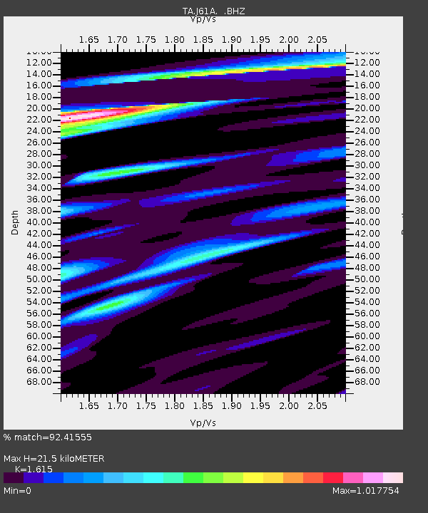
| Estimated Moho Depth: |
21.5 km |
| Estimated Crust Vp/Vs: |
1.62 |
| Assumed Crust Vp: |
6.419 km/s |
| Estimated Crust Vs: |
3.975 km/s |
| Estimated Crust Poisson's Ratio: |
0.19 |
|
| Radial Match: |
92.41555 % |
| Radial Bump: |
343 |
| Transverse Match: |
91.10349 % |
| Transverse Bump: |
400 |
| SOD ConfigId: |
626651 |
| Insert Time: |
2014-06-07 10:11:59.741 +0000 |
| GWidth: |
2.5 |
| Max Bumps: |
400 |
| Tol: |
0.001 |
|
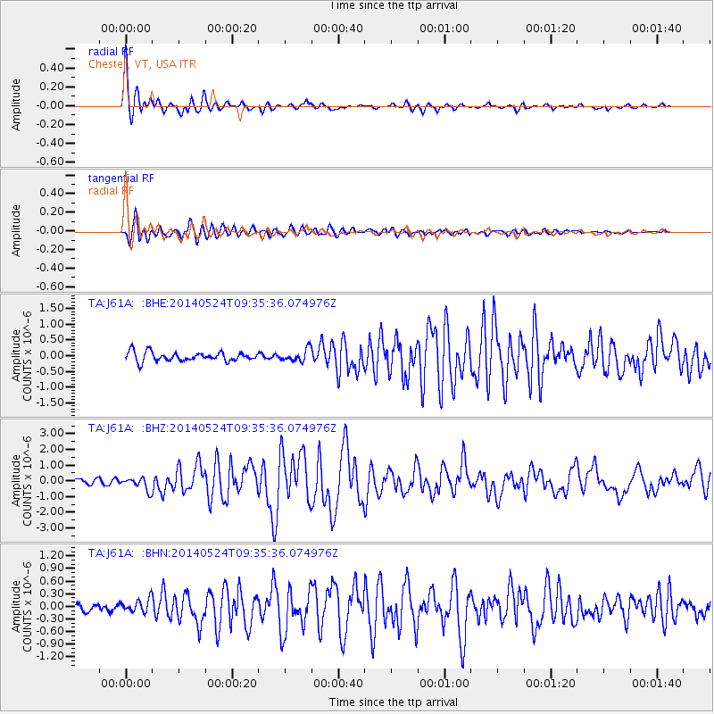
Signal To Noise
| Channel | StoN | STA | LTA |
| TA:J61A: :BHZ:20140524T09:35:36.074976Z | 2.6876576 | 4.1071928E-7 | 1.5281682E-7 |
| TA:J61A: :BHN:20140524T09:35:36.074976Z | 1.4556706 | 1.5907051E-7 | 1.0927645E-7 |
| TA:J61A: :BHE:20140524T09:35:36.074976Z | 1.3388367 | 1.9170412E-7 | 1.4318708E-7 |
| Arrivals |
| Ps | 2.1 SECOND |
| PpPs | 8.4 SECOND |
| PsPs/PpSs | 11 SECOND |


