You are here: Home > Network List > TA - USArray Transportable Network (new EarthScope stations) Stations List
> Station K47A Vremontville, MI, USA > Earthquake Result Viewer
K47A Vremontville, MI, USA - Earthquake Result Viewer
| Earthquake location: |
Aegean Sea |
| Earthquake latitude/longitude: |
40.3/25.5 |
| Earthquake time(UTC): |
2014/05/24 (144) 09:25:03 GMT |
| Earthquake Depth: |
10 km |
| Earthquake Magnitude: |
6.4 MWP, 6.4 M |
| Earthquake Catalog/Contributor: |
NEIC PDE/NEIC ALERT |
|
| Network: |
TA USArray Transportable Network (new EarthScope stations) |
| Station: |
K47A Vremontville, MI, USA |
| Lat/Lon: |
42.67 N/85.00 W |
| Elevation: |
275 m |
|
| Distance: |
76.2 deg |
| Az: |
314.642 deg |
| Baz: |
47.535 deg |
| Ray Param: |
0.05113817 |
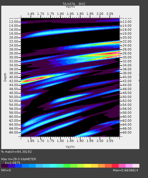
| Estimated Moho Depth: |
29.0 km |
| Estimated Crust Vp/Vs: |
2.10 |
| Assumed Crust Vp: |
6.483 km/s |
| Estimated Crust Vs: |
3.091 km/s |
| Estimated Crust Poisson's Ratio: |
0.35 |
|
| Radial Match: |
94.38192 % |
| Radial Bump: |
400 |
| Transverse Match: |
81.0554 % |
| Transverse Bump: |
400 |
| SOD ConfigId: |
626651 |
| Insert Time: |
2014-06-07 10:12:19.982 +0000 |
| GWidth: |
2.5 |
| Max Bumps: |
400 |
| Tol: |
0.001 |
|

Signal To Noise
| Channel | StoN | STA | LTA |
| TA:K47A: :BHZ:20140524T09:36:20.750024Z | 3.9975939 | 4.0679276E-7 | 1.017594E-7 |
| TA:K47A: :BHN:20140524T09:36:20.750024Z | 0.8282155 | 8.631961E-8 | 1.0422361E-7 |
| TA:K47A: :BHE:20140524T09:36:20.750024Z | 1.5638016 | 1.4870392E-7 | 9.509129E-8 |
| Arrivals |
| Ps | 5.0 SECOND |
| PpPs | 13 SECOND |
| PsPs/PpSs | 19 SECOND |


