You are here: Home > Network List > TA - USArray Transportable Network (new EarthScope stations) Stations List
> Station K63A Dunstable, MA, USA > Earthquake Result Viewer
K63A Dunstable, MA, USA - Earthquake Result Viewer
| Earthquake location: |
Aegean Sea |
| Earthquake latitude/longitude: |
40.3/25.5 |
| Earthquake time(UTC): |
2014/05/24 (144) 09:25:03 GMT |
| Earthquake Depth: |
10 km |
| Earthquake Magnitude: |
6.4 MWP, 6.4 M |
| Earthquake Catalog/Contributor: |
NEIC PDE/NEIC ALERT |
|
| Network: |
TA USArray Transportable Network (new EarthScope stations) |
| Station: |
K63A Dunstable, MA, USA |
| Lat/Lon: |
42.69 N/71.53 W |
| Elevation: |
68 m |
|
| Distance: |
68.5 deg |
| Az: |
308.123 deg |
| Baz: |
54.673 deg |
| Ray Param: |
0.05627613 |
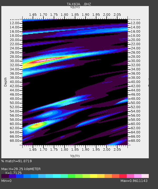
| Estimated Moho Depth: |
29.25 km |
| Estimated Crust Vp/Vs: |
1.71 |
| Assumed Crust Vp: |
6.419 km/s |
| Estimated Crust Vs: |
3.748 km/s |
| Estimated Crust Poisson's Ratio: |
0.24 |
|
| Radial Match: |
91.8719 % |
| Radial Bump: |
307 |
| Transverse Match: |
76.359055 % |
| Transverse Bump: |
400 |
| SOD ConfigId: |
626651 |
| Insert Time: |
2014-06-07 10:13:15.135 +0000 |
| GWidth: |
2.5 |
| Max Bumps: |
400 |
| Tol: |
0.001 |
|
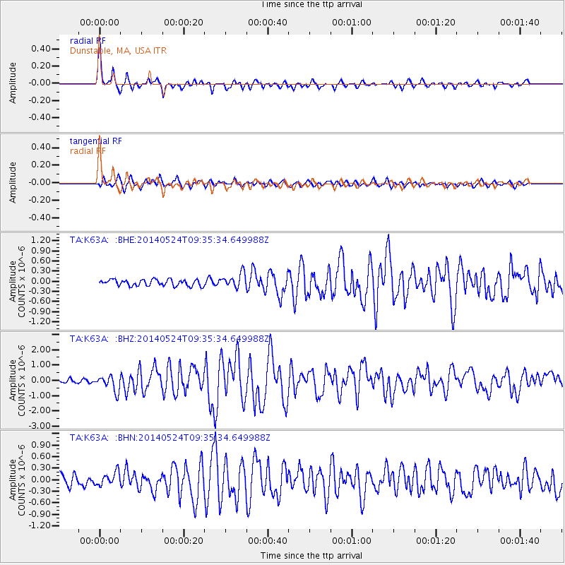
Signal To Noise
| Channel | StoN | STA | LTA |
| TA:K63A: :BHZ:20140524T09:35:34.649988Z | 3.352381 | 5.146492E-7 | 1.535175E-7 |
| TA:K63A: :BHN:20140524T09:35:34.649988Z | 1.1365914 | 1.7369852E-7 | 1.5282407E-7 |
| TA:K63A: :BHE:20140524T09:35:34.649988Z | 2.3787973 | 2.1760866E-7 | 9.1478434E-8 |
| Arrivals |
| Ps | 3.4 SECOND |
| PpPs | 12 SECOND |
| PsPs/PpSs | 15 SECOND |


