You are here: Home > Network List > TA - USArray Transportable Network (new EarthScope stations) Stations List
> Station L44A Lake County Forest Preserve, Grayslake, IL, USA > Earthquake Result Viewer
L44A Lake County Forest Preserve, Grayslake, IL, USA - Earthquake Result Viewer
| Earthquake location: |
Aegean Sea |
| Earthquake latitude/longitude: |
40.3/25.5 |
| Earthquake time(UTC): |
2014/05/24 (144) 09:25:03 GMT |
| Earthquake Depth: |
10 km |
| Earthquake Magnitude: |
6.4 MWP, 6.4 M |
| Earthquake Catalog/Contributor: |
NEIC PDE/NEIC ALERT |
|
| Network: |
TA USArray Transportable Network (new EarthScope stations) |
| Station: |
L44A Lake County Forest Preserve, Grayslake, IL, USA |
| Lat/Lon: |
42.18 N/87.91 W |
| Elevation: |
202 m |
|
| Distance: |
78.1 deg |
| Az: |
315.793 deg |
| Baz: |
45.832 deg |
| Ray Param: |
0.049851198 |
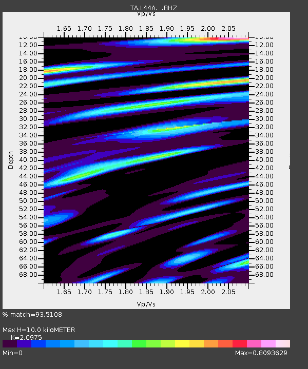
| Estimated Moho Depth: |
10.0 km |
| Estimated Crust Vp/Vs: |
2.10 |
| Assumed Crust Vp: |
6.483 km/s |
| Estimated Crust Vs: |
3.091 km/s |
| Estimated Crust Poisson's Ratio: |
0.35 |
|
| Radial Match: |
93.5108 % |
| Radial Bump: |
397 |
| Transverse Match: |
80.27258 % |
| Transverse Bump: |
400 |
| SOD ConfigId: |
626651 |
| Insert Time: |
2014-06-07 10:13:29.446 +0000 |
| GWidth: |
2.5 |
| Max Bumps: |
400 |
| Tol: |
0.001 |
|

Signal To Noise
| Channel | StoN | STA | LTA |
| TA:L44A: :BHZ:20140524T09:36:31.425012Z | 2.9804394 | 4.147712E-7 | 1.3916444E-7 |
| TA:L44A: :BHN:20140524T09:36:31.425012Z | 1.5602794 | 1.5115666E-7 | 9.687794E-8 |
| TA:L44A: :BHE:20140524T09:36:31.425012Z | 1.3589053 | 1.6947304E-7 | 1.2471291E-7 |
| Arrivals |
| Ps | 1.7 SECOND |
| PpPs | 4.7 SECOND |
| PsPs/PpSs | 6.4 SECOND |


