You are here: Home > Network List > II - Global Seismograph Network (GSN - IRIS/IDA) Stations List
> Station KURK Kurchatov, Kazakhstan > Earthquake Result Viewer
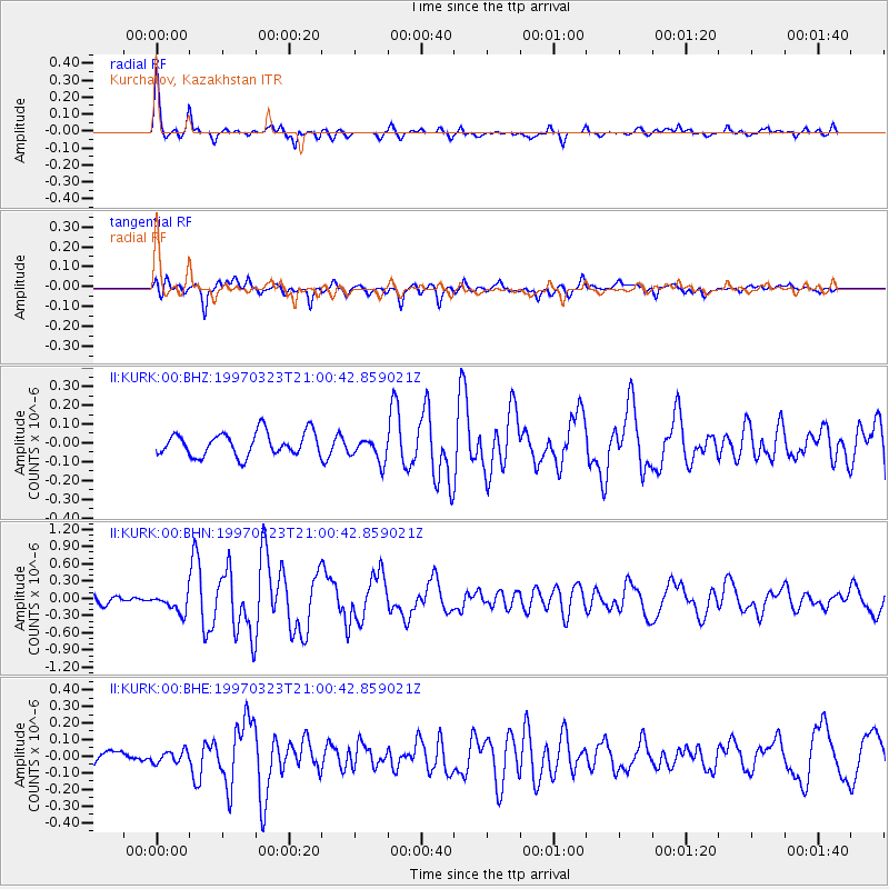
KURK Kurchatov, Kazakhstan - Earthquake Result Viewer
*The percent match for this event was below the threshold and hence no stack was calculated.
| Earthquake location: |
Northern Mid-Atlantic Ridge |
| Earthquake latitude/longitude: |
31.0/-41.5 |
| Earthquake time(UTC): |
1997/03/23 (082) 20:48:48 GMT |
| Earthquake Depth: |
10 km |
| Earthquake Magnitude: |
5.9 MS, 5.4 MB, 5.9 UNKNOWN, 5.9 MW |
| Earthquake Catalog/Contributor: |
WHDF/NEIC |
|
| Network: |
II Global Seismograph Network (GSN - IRIS/IDA) |
| Station: |
KURK Kurchatov, Kazakhstan |
| Lat/Lon: |
50.72 N/78.62 E |
| Elevation: |
184 m |
|
| Distance: |
83.0 deg |
| Az: |
33.623 deg |
| Baz: |
311.578 deg |
| Ray Param: |
$rayparam |
*The percent match for this event was below the threshold and hence was not used in the summary stack. |
|
| Radial Match: |
79.84284 % |
| Radial Bump: |
366 |
| Transverse Match: |
71.874664 % |
| Transverse Bump: |
400 |
| SOD ConfigId: |
4480 |
| Insert Time: |
2010-03-01 22:35:57.209 +0000 |
| GWidth: |
2.5 |
| Max Bumps: |
400 |
| Tol: |
0.001 |
|
Signal To Noise
| Channel | StoN | STA | LTA |
| II:KURK:00:BHN:19970323T21:00:42.859021Z | 2.3681526 | 1.6292898E-7 | 6.8800034E-8 |
| II:KURK:00:BHE:19970323T21:00:42.859021Z | 0.52387553 | 3.845674E-8 | 7.340817E-8 |
| II:KURK:00:BHZ:19970323T21:00:42.859021Z | 1.080664 | 6.706191E-8 | 6.20562E-8 |
| Arrivals |
| Ps | |
| PpPs | |
| PsPs/PpSs | |


