You are here: Home > Network List > TA - USArray Transportable Network (new EarthScope stations) Stations List
> Station N48A Decatur, IN, USA > Earthquake Result Viewer
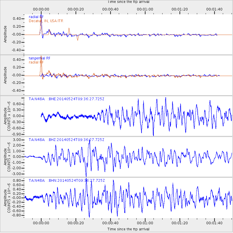
N48A Decatur, IN, USA - Earthquake Result Viewer

| Earthquake location: |
Aegean Sea |
| Earthquake latitude/longitude: |
40.3/25.5 |
| Earthquake time(UTC): |
2014/05/24 (144) 09:25:03 GMT |
| Earthquake Depth: |
10 km |
| Earthquake Magnitude: |
6.4 MWP, 6.4 M |
| Earthquake Catalog/Contributor: |
NEIC PDE/NEIC ALERT |
|
| Network: |
TA USArray Transportable Network (new EarthScope stations) |
| Station: |
N48A Decatur, IN, USA |
| Lat/Lon: |
40.86 N/85.03 W |
| Elevation: |
250 m |
|
| Distance: |
77.5 deg |
| Az: |
313.289 deg |
| Baz: |
47.208 deg |
| Ray Param: |
0.050304376 |
| Estimated Moho Depth: |
41.0 km |
| Estimated Crust Vp/Vs: |
1.71 |
| Assumed Crust Vp: |
6.498 km/s |
| Estimated Crust Vs: |
3.811 km/s |
| Estimated Crust Poisson's Ratio: |
0.24 |
|
| Radial Match: |
94.4622 % |
| Radial Bump: |
344 |
| Transverse Match: |
71.419205 % |
| Transverse Bump: |
400 |
| SOD ConfigId: |
626651 |
| Insert Time: |
2014-06-07 10:15:38.472 +0000 |
| GWidth: |
2.5 |
| Max Bumps: |
400 |
| Tol: |
0.001 |
|
Signal To Noise
| Channel | StoN | STA | LTA |
| TA:N48A: :BHZ:20140524T09:36:27.725Z | 4.4812236 | 4.5150006E-7 | 1.00753745E-7 |
| TA:N48A: :BHN:20140524T09:36:27.725Z | 2.1733294 | 1.4770634E-7 | 6.796317E-8 |
| TA:N48A: :BHE:20140524T09:36:27.725Z | 1.2308857 | 1.0653423E-7 | 8.655087E-8 |
| Arrivals |
| Ps | 4.6 SECOND |
| PpPs | 17 SECOND |
| PsPs/PpSs | 21 SECOND |


