You are here: Home > Network List > II - Global Seismograph Network (GSN - IRIS/IDA) Stations List
> Station KURK Kurchatov, Kazakhstan > Earthquake Result Viewer
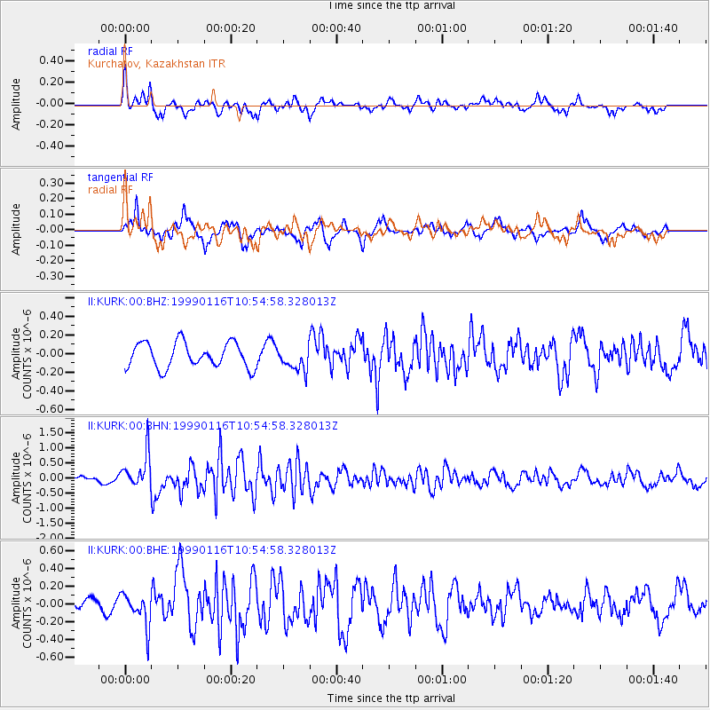
KURK Kurchatov, Kazakhstan - Earthquake Result Viewer
*The percent match for this event was below the threshold and hence no stack was calculated.
| Earthquake location: |
Gulf Of Alaska |
| Earthquake latitude/longitude: |
56.2/-147.4 |
| Earthquake time(UTC): |
1999/01/16 (016) 10:44:39 GMT |
| Earthquake Depth: |
21 km |
| Earthquake Magnitude: |
5.9 MB, 5.7 MS, 6.0 MW, 6.0 ME |
| Earthquake Catalog/Contributor: |
WHDF/NEIC |
|
| Network: |
II Global Seismograph Network (GSN - IRIS/IDA) |
| Station: |
KURK Kurchatov, Kazakhstan |
| Lat/Lon: |
50.72 N/78.62 E |
| Elevation: |
184 m |
|
| Distance: |
66.8 deg |
| Az: |
330.136 deg |
| Baz: |
25.936 deg |
| Ray Param: |
$rayparam |
*The percent match for this event was below the threshold and hence was not used in the summary stack. |
|
| Radial Match: |
65.40715 % |
| Radial Bump: |
335 |
| Transverse Match: |
65.29715 % |
| Transverse Bump: |
329 |
| SOD ConfigId: |
4480 |
| Insert Time: |
2010-03-01 22:36:12.005 +0000 |
| GWidth: |
2.5 |
| Max Bumps: |
400 |
| Tol: |
0.001 |
|
Signal To Noise
| Channel | StoN | STA | LTA |
| II:KURK:00:BHN:19990116T10:54:58.328013Z | 7.5754933 | 5.705132E-7 | 7.531037E-8 |
| II:KURK:00:BHE:19990116T10:54:58.328013Z | 1.2682681 | 1.8356451E-7 | 1.4473636E-7 |
| II:KURK:00:BHZ:19990116T10:54:58.328013Z | 0.96255726 | 1.288909E-7 | 1.3390466E-7 |
| Arrivals |
| Ps | |
| PpPs | |
| PsPs/PpSs | |


