You are here: Home > Network List > TA - USArray Transportable Network (new EarthScope stations) Stations List
> Station O60A Telford, PA, USA > Earthquake Result Viewer
O60A Telford, PA, USA - Earthquake Result Viewer
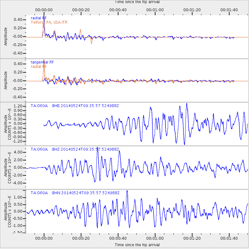
| Earthquake location: |
Aegean Sea |
| Earthquake latitude/longitude: |
40.3/25.5 |
| Earthquake time(UTC): |
2014/05/24 (144) 09:25:03 GMT |
| Earthquake Depth: |
10 km |
| Earthquake Magnitude: |
6.4 MWP, 6.4 M |
| Earthquake Catalog/Contributor: |
NEIC PDE/NEIC ALERT |
|
| Network: |
TA USArray Transportable Network (new EarthScope stations) |
| Station: |
O60A Telford, PA, USA |
| Lat/Lon: |
40.32 N/75.40 W |
| Elevation: |
70 m |
|
| Distance: |
72.2 deg |
| Az: |
307.951 deg |
| Baz: |
52.055 deg |
| Ray Param: |
0.053798903 |
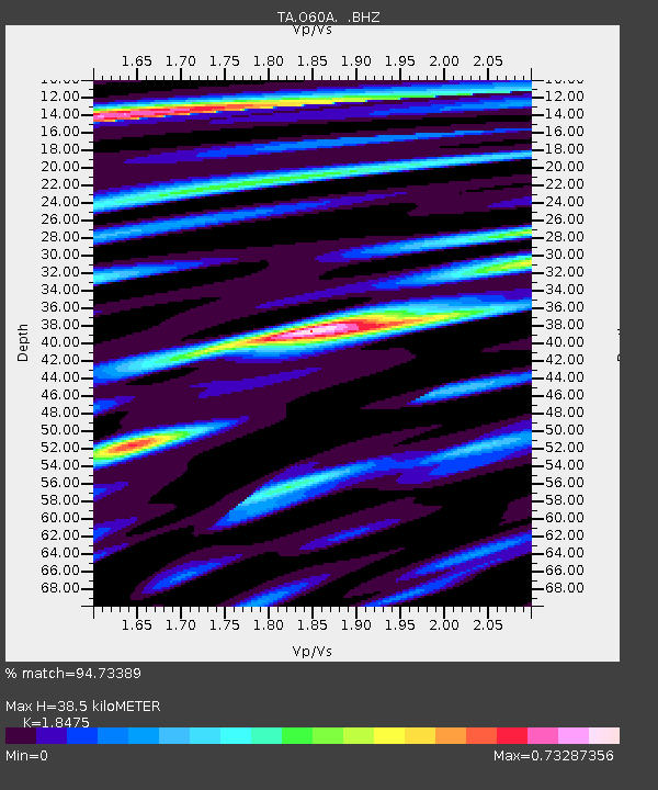
| Estimated Moho Depth: |
38.5 km |
| Estimated Crust Vp/Vs: |
1.85 |
| Assumed Crust Vp: |
6.283 km/s |
| Estimated Crust Vs: |
3.401 km/s |
| Estimated Crust Poisson's Ratio: |
0.29 |
|
| Radial Match: |
94.73389 % |
| Radial Bump: |
365 |
| Transverse Match: |
90.57888 % |
| Transverse Bump: |
382 |
| SOD ConfigId: |
626651 |
| Insert Time: |
2014-06-07 10:17:17.161 +0000 |
| GWidth: |
2.5 |
| Max Bumps: |
400 |
| Tol: |
0.001 |
|
Signal To Noise
| Channel | StoN | STA | LTA |
| TA:O60A: :BHZ:20140524T09:35:57.524988Z | 5.9827976 | 6.451153E-7 | 1.0782837E-7 |
| TA:O60A: :BHN:20140524T09:35:57.524988Z | 1.1681677 | 9.472012E-8 | 8.108436E-8 |
| TA:O60A: :BHE:20140524T09:35:57.524988Z | 2.4653075 | 2.3830415E-7 | 9.666306E-8 |
| Arrivals |
| Ps | 5.4 SECOND |
| PpPs | 17 SECOND |
| PsPs/PpSs | 22 SECOND |


