You are here: Home > Network List > TA - USArray Transportable Network (new EarthScope stations) Stations List
> Station POKR Poker Plat Research Range, AK, USA > Earthquake Result Viewer
POKR Poker Plat Research Range, AK, USA - Earthquake Result Viewer
| Earthquake location: |
Aegean Sea |
| Earthquake latitude/longitude: |
40.3/25.5 |
| Earthquake time(UTC): |
2014/05/24 (144) 09:25:03 GMT |
| Earthquake Depth: |
10 km |
| Earthquake Magnitude: |
6.4 MWP, 6.4 M |
| Earthquake Catalog/Contributor: |
NEIC PDE/NEIC ALERT |
|
| Network: |
TA USArray Transportable Network (new EarthScope stations) |
| Station: |
POKR Poker Plat Research Range, AK, USA |
| Lat/Lon: |
65.12 N/147.43 W |
| Elevation: |
501 m |
|
| Distance: |
74.8 deg |
| Az: |
356.887 deg |
| Baz: |
5.632 deg |
| Ray Param: |
0.052117404 |
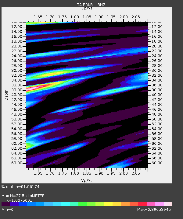
| Estimated Moho Depth: |
37.5 km |
| Estimated Crust Vp/Vs: |
1.61 |
| Assumed Crust Vp: |
6.566 km/s |
| Estimated Crust Vs: |
4.085 km/s |
| Estimated Crust Poisson's Ratio: |
0.18 |
|
| Radial Match: |
91.96174 % |
| Radial Bump: |
400 |
| Transverse Match: |
86.7819 % |
| Transverse Bump: |
400 |
| SOD ConfigId: |
626651 |
| Insert Time: |
2014-06-07 10:18:13.218 +0000 |
| GWidth: |
2.5 |
| Max Bumps: |
400 |
| Tol: |
0.001 |
|

Signal To Noise
| Channel | StoN | STA | LTA |
| TA:POKR: :BHZ:20140524T09:36:12.350Z | 2.3735857 | 2.1607669E-7 | 9.103386E-8 |
| TA:POKR: :BHN:20140524T09:36:12.350Z | 2.1755648 | 9.3661065E-8 | 4.305138E-8 |
| TA:POKR: :BHE:20140524T09:36:12.350Z | 1.3484144 | 7.4467444E-8 | 5.5225932E-8 |
| Arrivals |
| Ps | 3.6 SECOND |
| PpPs | 14 SECOND |
| PsPs/PpSs | 18 SECOND |


