You are here: Home > Network List > TA - USArray Transportable Network (new EarthScope stations) Stations List
> Station S59A Mechanicsville, VA, USA > Earthquake Result Viewer
S59A Mechanicsville, VA, USA - Earthquake Result Viewer
| Earthquake location: |
Aegean Sea |
| Earthquake latitude/longitude: |
40.3/25.5 |
| Earthquake time(UTC): |
2014/05/24 (144) 09:25:03 GMT |
| Earthquake Depth: |
10 km |
| Earthquake Magnitude: |
6.4 MWP, 6.4 M |
| Earthquake Catalog/Contributor: |
NEIC PDE/NEIC ALERT |
|
| Network: |
TA USArray Transportable Network (new EarthScope stations) |
| Station: |
S59A Mechanicsville, VA, USA |
| Lat/Lon: |
37.46 N/77.18 W |
| Elevation: |
40 m |
|
| Distance: |
75.1 deg |
| Az: |
306.529 deg |
| Baz: |
50.547 deg |
| Ray Param: |
0.05189552 |
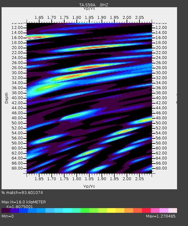
| Estimated Moho Depth: |
16.0 km |
| Estimated Crust Vp/Vs: |
1.61 |
| Assumed Crust Vp: |
6.565 km/s |
| Estimated Crust Vs: |
4.084 km/s |
| Estimated Crust Poisson's Ratio: |
0.18 |
|
| Radial Match: |
93.601074 % |
| Radial Bump: |
400 |
| Transverse Match: |
82.842674 % |
| Transverse Bump: |
400 |
| SOD ConfigId: |
626651 |
| Insert Time: |
2014-06-07 10:19:48.505 +0000 |
| GWidth: |
2.5 |
| Max Bumps: |
400 |
| Tol: |
0.001 |
|
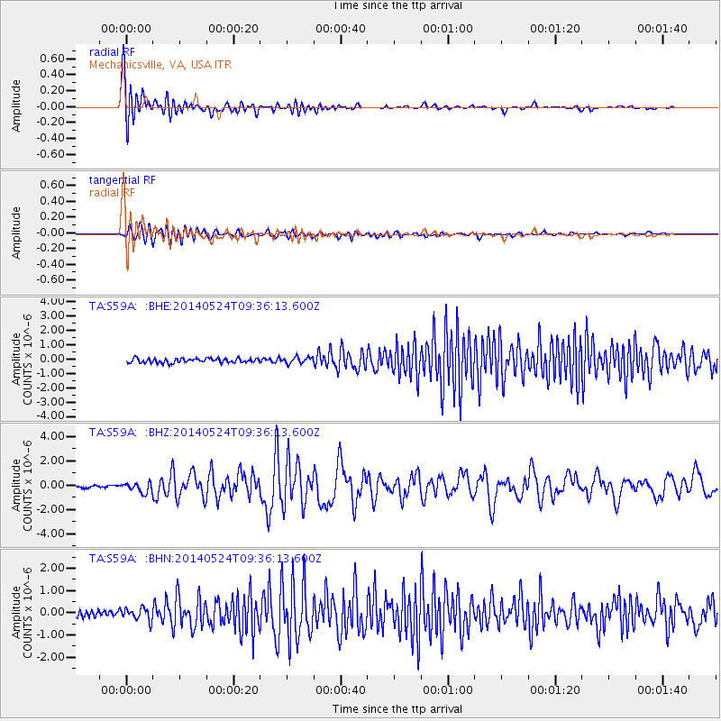
Signal To Noise
| Channel | StoN | STA | LTA |
| TA:S59A: :BHZ:20140524T09:36:13.600Z | 4.2969346 | 4.20218E-7 | 9.7794825E-8 |
| TA:S59A: :BHN:20140524T09:36:13.600Z | 2.0915756 | 2.7493903E-7 | 1.3145068E-7 |
| TA:S59A: :BHE:20140524T09:36:13.600Z | 1.719828 | 2.564372E-7 | 1.4910631E-7 |
| Arrivals |
| Ps | 1.5 SECOND |
| PpPs | 6.1 SECOND |
| PsPs/PpSs | 7.7 SECOND |


