You are here: Home > Network List > TA - USArray Transportable Network (new EarthScope stations) Stations List
> Station T59A Double 'B' Farms, VA, USA > Earthquake Result Viewer
T59A Double 'B' Farms, VA, USA - Earthquake Result Viewer
| Earthquake location: |
Aegean Sea |
| Earthquake latitude/longitude: |
40.3/25.5 |
| Earthquake time(UTC): |
2014/05/24 (144) 09:25:03 GMT |
| Earthquake Depth: |
10 km |
| Earthquake Magnitude: |
6.4 MWP, 6.4 M |
| Earthquake Catalog/Contributor: |
NEIC PDE/NEIC ALERT |
|
| Network: |
TA USArray Transportable Network (new EarthScope stations) |
| Station: |
T59A Double 'B' Farms, VA, USA |
| Lat/Lon: |
36.97 N/77.55 W |
| Elevation: |
63 m |
|
| Distance: |
75.6 deg |
| Az: |
306.341 deg |
| Baz: |
50.272 deg |
| Ray Param: |
0.05153522 |
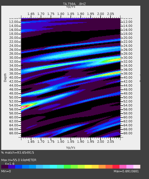
| Estimated Moho Depth: |
55.0 km |
| Estimated Crust Vp/Vs: |
1.60 |
| Assumed Crust Vp: |
6.565 km/s |
| Estimated Crust Vs: |
4.103 km/s |
| Estimated Crust Poisson's Ratio: |
0.18 |
|
| Radial Match: |
93.654915 % |
| Radial Bump: |
400 |
| Transverse Match: |
75.01834 % |
| Transverse Bump: |
400 |
| SOD ConfigId: |
626651 |
| Insert Time: |
2014-06-07 10:20:47.353 +0000 |
| GWidth: |
2.5 |
| Max Bumps: |
400 |
| Tol: |
0.001 |
|

Signal To Noise
| Channel | StoN | STA | LTA |
| TA:T59A: :BHZ:20140524T09:36:17.399988Z | 4.143003 | 4.15054E-7 | 1.00181914E-7 |
| TA:T59A: :BHN:20140524T09:36:17.399988Z | 1.0529275 | 9.370795E-8 | 8.899754E-8 |
| TA:T59A: :BHE:20140524T09:36:17.399988Z | 1.9145105 | 1.4334755E-7 | 7.487426E-8 |
| Arrivals |
| Ps | 5.2 SECOND |
| PpPs | 21 SECOND |
| PsPs/PpSs | 26 SECOND |


