You are here: Home > Network List > TA - USArray Transportable Network (new EarthScope stations) Stations List
> Station X43A Marvell, AR, USA > Earthquake Result Viewer
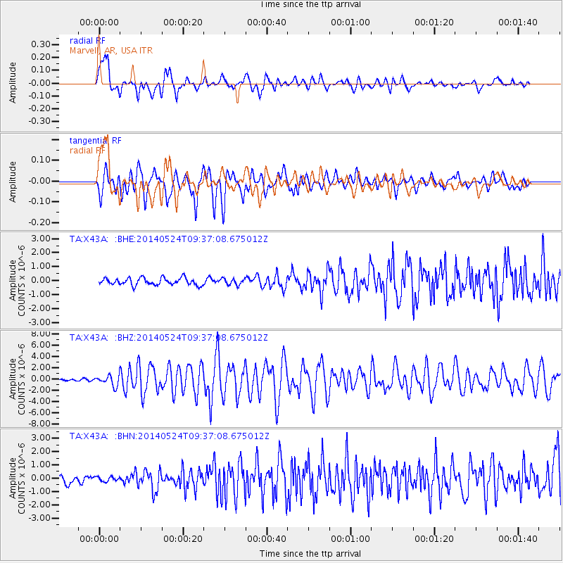
X43A Marvell, AR, USA - Earthquake Result Viewer
*The percent match for this event was below the threshold and hence no stack was calculated.
| Earthquake location: |
Aegean Sea |
| Earthquake latitude/longitude: |
40.3/25.5 |
| Earthquake time(UTC): |
2014/05/24 (144) 09:25:03 GMT |
| Earthquake Depth: |
10 km |
| Earthquake Magnitude: |
6.4 MWP, 6.4 M |
| Earthquake Catalog/Contributor: |
NEIC PDE/NEIC ALERT |
|
| Network: |
TA USArray Transportable Network (new EarthScope stations) |
| Station: |
X43A Marvell, AR, USA |
| Lat/Lon: |
34.52 N/90.88 W |
| Elevation: |
53 m |
|
| Distance: |
85.2 deg |
| Az: |
312.045 deg |
| Baz: |
43.449 deg |
| Ray Param: |
$rayparam |
*The percent match for this event was below the threshold and hence was not used in the summary stack. |
|
| Radial Match: |
85.187775 % |
| Radial Bump: |
400 |
| Transverse Match: |
79.586845 % |
| Transverse Bump: |
400 |
| SOD ConfigId: |
626651 |
| Insert Time: |
2014-06-07 10:22:48.283 +0000 |
| GWidth: |
2.5 |
| Max Bumps: |
400 |
| Tol: |
0.001 |
|
Signal To Noise
| Channel | StoN | STA | LTA |
| TA:X43A: :BHZ:20140524T09:37:08.675012Z | 5.9990067 | 9.40969E-7 | 1.5685413E-7 |
| TA:X43A: :BHN:20140524T09:37:08.675012Z | 0.741591 | 1.767267E-7 | 2.383075E-7 |
| TA:X43A: :BHE:20140524T09:37:08.675012Z | 0.8867788 | 2.2370365E-7 | 2.5226547E-7 |
| Arrivals |
| Ps | |
| PpPs | |
| PsPs/PpSs | |


