You are here: Home > Network List > AF - Africa Array Stations List
> Station TEBE Entebbe, Uganda > Earthquake Result Viewer
TEBE Entebbe, Uganda - Earthquake Result Viewer
| Earthquake location: |
Southern Sumatra, Indonesia |
| Earthquake latitude/longitude: |
-0.8/98.7 |
| Earthquake time(UTC): |
2015/03/03 (062) 10:37:31 GMT |
| Earthquake Depth: |
38 km |
| Earthquake Magnitude: |
6.4 MWP, 6.4 MO |
| Earthquake Catalog/Contributor: |
NEIC PDE/NEIC ALERT |
|
| Network: |
AF Africa Array |
| Station: |
TEBE Entebbe, Uganda |
| Lat/Lon: |
0.05 N/32.48 E |
| Elevation: |
1132 m |
|
| Distance: |
66.2 deg |
| Az: |
270.394 deg |
| Baz: |
90.856 deg |
| Ray Param: |
0.057688687 |
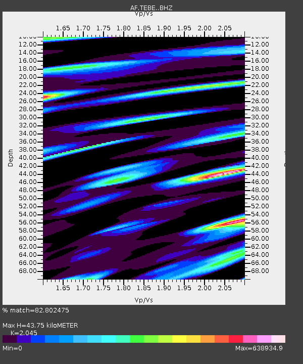
| Estimated Moho Depth: |
43.75 km |
| Estimated Crust Vp/Vs: |
2.05 |
| Assumed Crust Vp: |
6.642 km/s |
| Estimated Crust Vs: |
3.248 km/s |
| Estimated Crust Poisson's Ratio: |
0.34 |
|
| Radial Match: |
82.802475 % |
| Radial Bump: |
400 |
| Transverse Match: |
82.8024 % |
| Transverse Bump: |
400 |
| SOD ConfigId: |
7019011 |
| Insert Time: |
2019-04-17 04:41:05.117 +0000 |
| GWidth: |
2.5 |
| Max Bumps: |
400 |
| Tol: |
0.001 |
|

Signal To Noise
| Channel | StoN | STA | LTA |
| AF:TEBE: :BHZ:20150303T10:47:45.415027Z | 1.4771774 | 8.7688155E-12 | 5.936197E-12 |
| AF:TEBE: :BHN:20150303T10:47:45.415027Z | 0.99119514 | 3.2390971E-12 | 3.2678703E-12 |
| AF:TEBE: :BHE:20150303T10:47:45.415027Z | 1.0498563 | 7.1118925E-6 | 6.774158E-6 |
| Arrivals |
| Ps | 7.1 SECOND |
| PpPs | 19 SECOND |
| PsPs/PpSs | 26 SECOND |


