You are here: Home > Network List > CB - China National Seismic Network Stations List
> Station WHN Wuhantai,Hubei Province > Earthquake Result Viewer
WHN Wuhantai,Hubei Province - Earthquake Result Viewer
| Earthquake location: |
Southern Sumatra, Indonesia |
| Earthquake latitude/longitude: |
-0.8/98.7 |
| Earthquake time(UTC): |
2015/03/03 (062) 10:37:31 GMT |
| Earthquake Depth: |
38 km |
| Earthquake Magnitude: |
6.4 MWP, 6.4 MO |
| Earthquake Catalog/Contributor: |
NEIC PDE/NEIC ALERT |
|
| Network: |
CB China National Seismic Network |
| Station: |
WHN Wuhantai,Hubei Province |
| Lat/Lon: |
30.54 N/114.35 E |
| Elevation: |
80 m |
|
| Distance: |
34.5 deg |
| Az: |
24.245 deg |
| Baz: |
208.419 deg |
| Ray Param: |
0.077627204 |
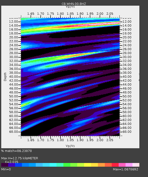
| Estimated Moho Depth: |
12.75 km |
| Estimated Crust Vp/Vs: |
2.04 |
| Assumed Crust Vp: |
6.276 km/s |
| Estimated Crust Vs: |
3.084 km/s |
| Estimated Crust Poisson's Ratio: |
0.34 |
|
| Radial Match: |
86.23878 % |
| Radial Bump: |
316 |
| Transverse Match: |
65.55369 % |
| Transverse Bump: |
400 |
| SOD ConfigId: |
7019011 |
| Insert Time: |
2019-04-17 04:41:38.820 +0000 |
| GWidth: |
2.5 |
| Max Bumps: |
400 |
| Tol: |
0.001 |
|

Signal To Noise
| Channel | StoN | STA | LTA |
| CB:WHN:00:BHZ:20150303T10:43:45.550006Z | 4.982997 | 1.131967E-6 | 2.271659E-7 |
| CB:WHN:00:BHN:20150303T10:43:45.550006Z | 3.1536365 | 5.987379E-7 | 1.8985637E-7 |
| CB:WHN:00:BHE:20150303T10:43:45.550006Z | 3.3418589 | 4.5583664E-7 | 1.3640212E-7 |
| Arrivals |
| Ps | 2.2 SECOND |
| PpPs | 5.8 SECOND |
| PsPs/PpSs | 8.0 SECOND |


