You are here: Home > Network List > UW - Pacific Northwest Regional Seismic Network Stations List
> Station UMAT Pilot Rock, OR, USA > Earthquake Result Viewer
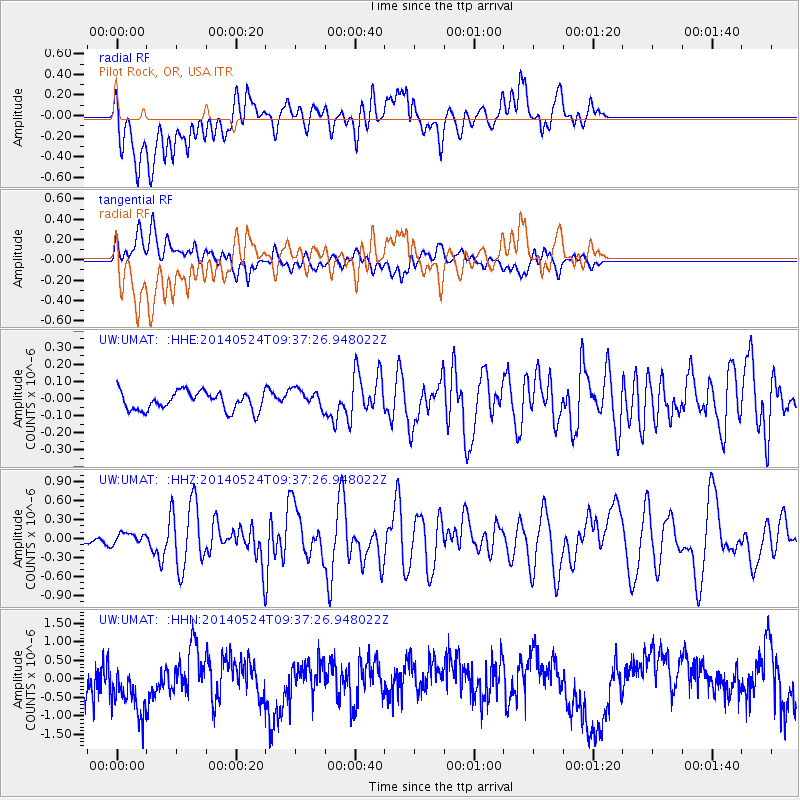
UMAT Pilot Rock, OR, USA - Earthquake Result Viewer
*The percent match for this event was below the threshold and hence no stack was calculated.
| Earthquake location: |
Aegean Sea |
| Earthquake latitude/longitude: |
40.3/25.5 |
| Earthquake time(UTC): |
2014/05/24 (144) 09:25:03 GMT |
| Earthquake Depth: |
10 km |
| Earthquake Magnitude: |
6.4 MWP, 6.4 M |
| Earthquake Catalog/Contributor: |
NEIC PDE/NEIC ALERT |
|
| Network: |
UW Pacific Northwest Regional Seismic Network |
| Station: |
UMAT Pilot Rock, OR, USA |
| Lat/Lon: |
45.29 N/118.96 W |
| Elevation: |
1318 m |
|
| Distance: |
89.0 deg |
| Az: |
335.741 deg |
| Baz: |
26.427 deg |
| Ray Param: |
$rayparam |
*The percent match for this event was below the threshold and hence was not used in the summary stack. |
|
| Radial Match: |
46.643364 % |
| Radial Bump: |
400 |
| Transverse Match: |
50.483673 % |
| Transverse Bump: |
400 |
| SOD ConfigId: |
626651 |
| Insert Time: |
2014-06-07 10:28:51.673 +0000 |
| GWidth: |
2.5 |
| Max Bumps: |
400 |
| Tol: |
0.001 |
|
Signal To Noise
| Channel | StoN | STA | LTA |
| UW:UMAT: :HHZ:20140524T09:37:26.948022Z | 1.1950111 | 8.823083E-8 | 7.383264E-8 |
| UW:UMAT: :HHN:20140524T09:37:26.948022Z | 1.4767019 | 8.9685443E-7 | 6.073362E-7 |
| UW:UMAT: :HHE:20140524T09:37:26.948022Z | 1.081474 | 5.8578287E-8 | 5.4165234E-8 |
| Arrivals |
| Ps | |
| PpPs | |
| PsPs/PpSs | |


