You are here: Home > Network List > KN - Kyrgyz Seismic Telemetry Network Stations List
> Station KBK KN.KBK > Earthquake Result Viewer
KBK KN.KBK - Earthquake Result Viewer
| Earthquake location: |
Southern Sumatra, Indonesia |
| Earthquake latitude/longitude: |
-0.8/98.7 |
| Earthquake time(UTC): |
2015/03/03 (062) 10:37:31 GMT |
| Earthquake Depth: |
38 km |
| Earthquake Magnitude: |
6.4 MWP, 6.4 MO |
| Earthquake Catalog/Contributor: |
NEIC PDE/NEIC ALERT |
|
| Network: |
KN Kyrgyz Seismic Telemetry Network |
| Station: |
KBK KN.KBK |
| Lat/Lon: |
42.66 N/74.95 E |
| Elevation: |
1760 m |
|
| Distance: |
48.2 deg |
| Az: |
336.515 deg |
| Baz: |
147.305 deg |
| Ray Param: |
0.06941517 |
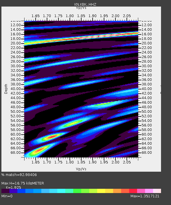
| Estimated Moho Depth: |
16.75 km |
| Estimated Crust Vp/Vs: |
1.92 |
| Assumed Crust Vp: |
6.306 km/s |
| Estimated Crust Vs: |
3.276 km/s |
| Estimated Crust Poisson's Ratio: |
0.32 |
|
| Radial Match: |
92.98406 % |
| Radial Bump: |
400 |
| Transverse Match: |
88.55025 % |
| Transverse Bump: |
400 |
| SOD ConfigId: |
7019011 |
| Insert Time: |
2019-04-17 04:42:38.069 +0000 |
| GWidth: |
2.5 |
| Max Bumps: |
400 |
| Tol: |
0.001 |
|

Signal To Noise
| Channel | StoN | STA | LTA |
| KN:KBK: :HHZ:20150303T10:45:38.110004Z | 15.747145 | 1.62692E-6 | 1.0331524E-7 |
| KN:KBK: :HHN:20150303T10:45:38.110004Z | 13.235841 | 6.792048E-7 | 5.1315574E-8 |
| KN:KBK: :HHE:20150303T10:45:38.110004Z | 4.7092724 | 5.1619253E-7 | 1.0961194E-7 |
| Arrivals |
| Ps | 2.6 SECOND |
| PpPs | 7.4 SECOND |
| PsPs/PpSs | 10.0 SECOND |


