You are here: Home > Network List > KO - Kandilli Observatory Digital Broadband Seismic Network Stations List
> Station SNOP Sinop-Turkey > Earthquake Result Viewer
SNOP Sinop-Turkey - Earthquake Result Viewer
| Earthquake location: |
Southern Sumatra, Indonesia |
| Earthquake latitude/longitude: |
-0.8/98.7 |
| Earthquake time(UTC): |
2015/03/03 (062) 10:37:31 GMT |
| Earthquake Depth: |
38 km |
| Earthquake Magnitude: |
6.4 MWP, 6.4 MO |
| Earthquake Catalog/Contributor: |
NEIC PDE/NEIC ALERT |
|
| Network: |
KO Kandilli Observatory Digital Broadband Seismic Network |
| Station: |
SNOP Sinop-Turkey |
| Lat/Lon: |
42.02 N/35.21 E |
| Elevation: |
180 m |
|
| Distance: |
71.1 deg |
| Az: |
315.188 deg |
| Baz: |
108.96 deg |
| Ray Param: |
0.054473262 |
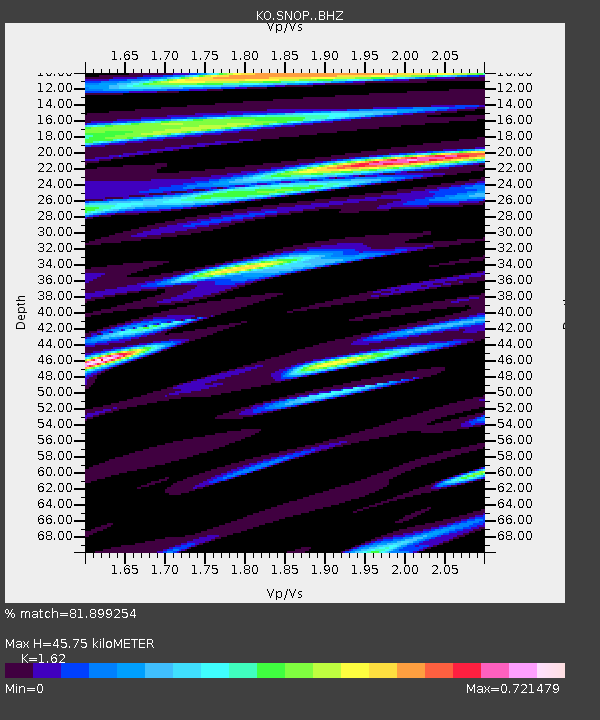
| Estimated Moho Depth: |
45.75 km |
| Estimated Crust Vp/Vs: |
1.62 |
| Assumed Crust Vp: |
5.806 km/s |
| Estimated Crust Vs: |
3.584 km/s |
| Estimated Crust Poisson's Ratio: |
0.19 |
|
| Radial Match: |
81.899254 % |
| Radial Bump: |
398 |
| Transverse Match: |
69.915764 % |
| Transverse Bump: |
400 |
| SOD ConfigId: |
7019011 |
| Insert Time: |
2019-04-17 04:42:46.368 +0000 |
| GWidth: |
2.5 |
| Max Bumps: |
400 |
| Tol: |
0.001 |
|

Signal To Noise
| Channel | StoN | STA | LTA |
| KO:SNOP: :BHZ:20150303T10:48:15.520007Z | 4.8623734 | 8.3596024E-7 | 1.7192433E-7 |
| KO:SNOP: :BHN:20150303T10:48:15.520007Z | 0.6167311 | 1.1461973E-7 | 1.858504E-7 |
| KO:SNOP: :BHE:20150303T10:48:15.520007Z | 4.047597 | 5.7929356E-7 | 1.4312037E-7 |
| Arrivals |
| Ps | 5.0 SECOND |
| PpPs | 20 SECOND |
| PsPs/PpSs | 25 SECOND |


