You are here: Home > Network List > XL12 - Hangay Dome, Mongolia Stations List
> Station HV10 HV10 > Earthquake Result Viewer
HV10 HV10 - Earthquake Result Viewer
| Earthquake location: |
Southern Sumatra, Indonesia |
| Earthquake latitude/longitude: |
-0.8/98.7 |
| Earthquake time(UTC): |
2015/03/03 (062) 10:37:31 GMT |
| Earthquake Depth: |
38 km |
| Earthquake Magnitude: |
6.4 MWP, 6.4 MO |
| Earthquake Catalog/Contributor: |
NEIC PDE/NEIC ALERT |
|
| Network: |
XL Hangay Dome, Mongolia |
| Station: |
HV10 HV10 |
| Lat/Lon: |
51.57 N/100.45 E |
| Elevation: |
1685 m |
|
| Distance: |
52.2 deg |
| Az: |
1.375 deg |
| Baz: |
182.204 deg |
| Ray Param: |
0.066856764 |
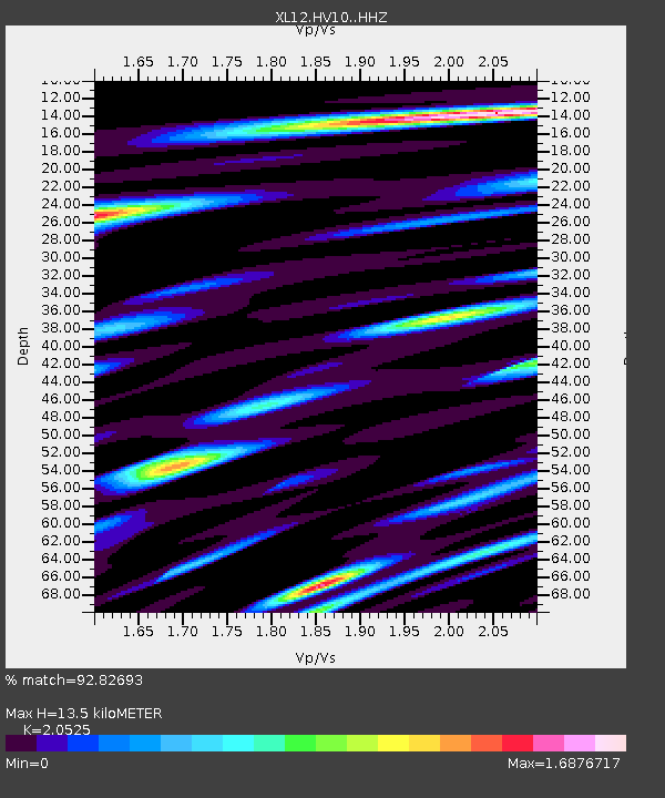
| Estimated Moho Depth: |
13.5 km |
| Estimated Crust Vp/Vs: |
2.05 |
| Assumed Crust Vp: |
6.419 km/s |
| Estimated Crust Vs: |
3.128 km/s |
| Estimated Crust Poisson's Ratio: |
0.34 |
|
| Radial Match: |
92.82693 % |
| Radial Bump: |
400 |
| Transverse Match: |
78.26278 % |
| Transverse Bump: |
400 |
| SOD ConfigId: |
7019011 |
| Insert Time: |
2019-04-17 04:44:04.352 +0000 |
| GWidth: |
2.5 |
| Max Bumps: |
400 |
| Tol: |
0.001 |
|

Signal To Noise
| Channel | StoN | STA | LTA |
| XL:HV10: :HHZ:20150303T10:46:07.68999Z | 12.855926 | 8.9039355E-7 | 6.9259386E-8 |
| XL:HV10: :HHN:20150303T10:46:07.68999Z | 8.549356 | 5.832525E-7 | 6.82218E-8 |
| XL:HV10: :HHE:20150303T10:46:07.68999Z | 1.6183074 | 1.02025844E-7 | 6.304479E-8 |
| Arrivals |
| Ps | 2.3 SECOND |
| PpPs | 6.1 SECOND |
| PsPs/PpSs | 8.4 SECOND |


