You are here: Home > Network List > XL12 - Hangay Dome, Mongolia Stations List
> Station HV26 HV26 > Earthquake Result Viewer
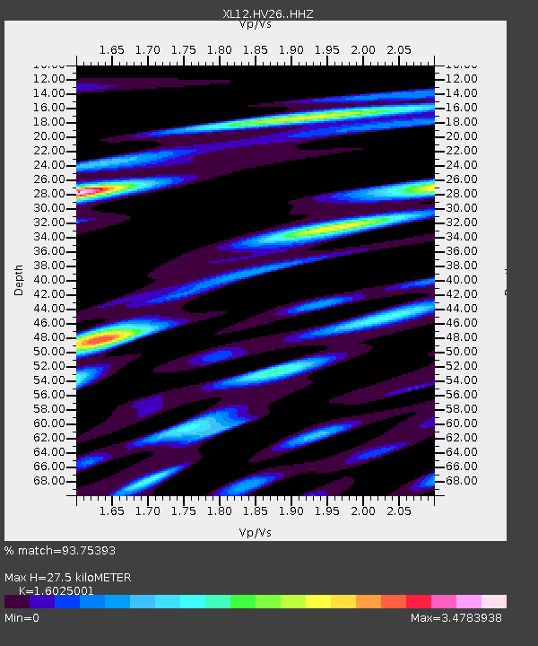
HV26 HV26 - Earthquake Result Viewer
| Earthquake location: |
Southern Sumatra, Indonesia |
| Earthquake latitude/longitude: |
-0.8/98.7 |
| Earthquake time(UTC): |
2015/03/03 (062) 10:37:31 GMT |
| Earthquake Depth: |
38 km |
| Earthquake Magnitude: |
6.4 MWP, 6.4 MO |
| Earthquake Catalog/Contributor: |
NEIC PDE/NEIC ALERT |
|
| Network: |
XL Hangay Dome, Mongolia |
| Station: |
HV26 HV26 |
| Lat/Lon: |
50.62 N/101.86 E |
| Elevation: |
1158 m |
|
| Distance: |
51.3 deg |
| Az: |
2.572 deg |
| Baz: |
184.04 deg |
| Ray Param: |
0.067446515 |
| Estimated Moho Depth: |
27.5 km |
| Estimated Crust Vp/Vs: |
1.60 |
| Assumed Crust Vp: |
6.419 km/s |
| Estimated Crust Vs: |
4.006 km/s |
| Estimated Crust Poisson's Ratio: |
0.18 |
|
| Radial Match: |
93.75393 % |
| Radial Bump: |
400 |
| Transverse Match: |
89.522156 % |
| Transverse Bump: |
400 |
| SOD ConfigId: |
7019011 |
| Insert Time: |
2019-04-17 04:44:21.268 +0000 |
| GWidth: |
2.5 |
| Max Bumps: |
400 |
| Tol: |
0.001 |
|

Signal To Noise
| Channel | StoN | STA | LTA |
| XL:HV26: :HHZ:20150303T10:46:00.978992Z | 25.611153 | 1.6243364E-6 | 6.342301E-8 |
| XL:HV26: :HHN:20150303T10:46:00.978992Z | 11.153368 | 1.1577924E-6 | 1.0380652E-7 |
| XL:HV26: :HHE:20150303T10:46:00.978992Z | 5.61567 | 6.248911E-7 | 1.1127631E-7 |
| Arrivals |
| Ps | 2.7 SECOND |
| PpPs | 10 SECOND |
| PsPs/PpSs | 13 SECOND |


